You are here: Home > Network List > CI - Caltech Regional Seismic Network Stations List
> Station SLA SLA, Trona, CA, USA > Earthquake Result Viewer
SLA SLA, Trona, CA, USA - Earthquake Result Viewer
| Earthquake location: |
South Of Fiji Islands |
| Earthquake latitude/longitude: |
-19.3/176.1 |
| Earthquake time(UTC): |
2017/01/03 (003) 21:52:31 GMT |
| Earthquake Depth: |
17 km |
| Earthquake Magnitude: |
6.9 Mww |
| Earthquake Catalog/Contributor: |
NEIC PDE/us |
|
| Network: |
CI Caltech Regional Seismic Network |
| Station: |
SLA SLA, Trona, CA, USA |
| Lat/Lon: |
35.89 N/117.28 W |
| Elevation: |
1174 m |
|
| Distance: |
83.6 deg |
| Az: |
48.614 deg |
| Baz: |
240.757 deg |
| Ray Param: |
0.046071492 |
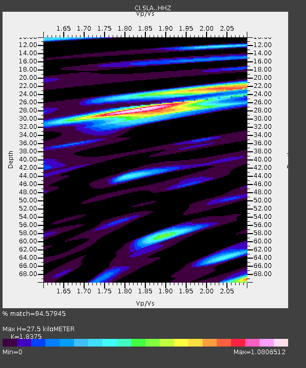
| Estimated Moho Depth: |
27.5 km |
| Estimated Crust Vp/Vs: |
1.84 |
| Assumed Crust Vp: |
6.276 km/s |
| Estimated Crust Vs: |
3.415 km/s |
| Estimated Crust Poisson's Ratio: |
0.29 |
|
| Radial Match: |
94.57945 % |
| Radial Bump: |
400 |
| Transverse Match: |
91.49982 % |
| Transverse Bump: |
400 |
| SOD ConfigId: |
11737051 |
| Insert Time: |
2019-04-26 12:38:09.850 +0000 |
| GWidth: |
2.5 |
| Max Bumps: |
400 |
| Tol: |
0.001 |
|
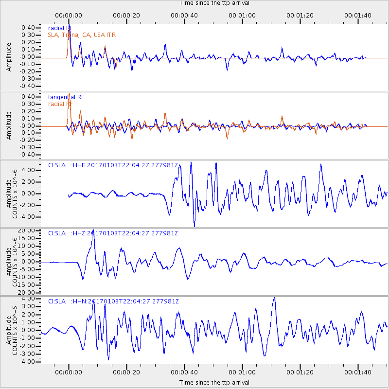
Signal To Noise
| Channel | StoN | STA | LTA |
| CI:SLA: :HHZ:20170103T22:04:27.277981Z | 19.015396 | 3.342729E-6 | 1.7579066E-7 |
| CI:SLA: :HHN:20170103T22:04:27.277981Z | 4.9149375 | 8.6946255E-7 | 1.7690206E-7 |
| CI:SLA: :HHE:20170103T22:04:27.277981Z | 3.9806342 | 1.0870905E-6 | 2.730948E-7 |
| Arrivals |
| Ps | 3.8 SECOND |
| PpPs | 12 SECOND |
| PsPs/PpSs | 16 SECOND |


