You are here: Home > Network List > CN - Canadian National Seismograph Network Stations List
> Station OZB Mt. Ozzard, BC, CA > Earthquake Result Viewer
OZB Mt. Ozzard, BC, CA - Earthquake Result Viewer
| Earthquake location: |
South Of Fiji Islands |
| Earthquake latitude/longitude: |
-19.3/176.1 |
| Earthquake time(UTC): |
2017/01/03 (003) 21:52:31 GMT |
| Earthquake Depth: |
17 km |
| Earthquake Magnitude: |
6.9 Mww |
| Earthquake Catalog/Contributor: |
NEIC PDE/us |
|
| Network: |
CN Canadian National Seismograph Network |
| Station: |
OZB Mt. Ozzard, BC, CA |
| Lat/Lon: |
48.96 N/125.50 W |
| Elevation: |
614 m |
|
| Distance: |
85.5 deg |
| Az: |
34.29 deg |
| Baz: |
233.826 deg |
| Ray Param: |
0.044699267 |
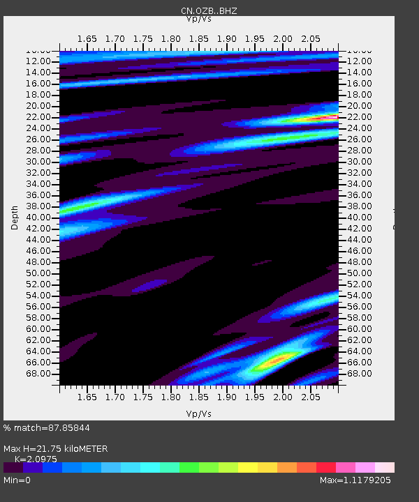
| Estimated Moho Depth: |
21.75 km |
| Estimated Crust Vp/Vs: |
2.10 |
| Assumed Crust Vp: |
6.391 km/s |
| Estimated Crust Vs: |
3.047 km/s |
| Estimated Crust Poisson's Ratio: |
0.35 |
|
| Radial Match: |
87.85844 % |
| Radial Bump: |
400 |
| Transverse Match: |
68.70788 % |
| Transverse Bump: |
400 |
| SOD ConfigId: |
11737051 |
| Insert Time: |
2019-04-26 12:38:47.965 +0000 |
| GWidth: |
2.5 |
| Max Bumps: |
400 |
| Tol: |
0.001 |
|

Signal To Noise
| Channel | StoN | STA | LTA |
| CN:OZB: :BHZ:20170103T22:04:37.02499Z | 9.76929 | 3.5352462E-6 | 3.618734E-7 |
| CN:OZB: :BHN:20170103T22:04:37.02499Z | 1.4669776 | 4.5866602E-7 | 3.1266055E-7 |
| CN:OZB: :BHE:20170103T22:04:37.02499Z | 2.861617 | 1.3232266E-6 | 4.6240518E-7 |
| Arrivals |
| Ps | 3.8 SECOND |
| PpPs | 10 SECOND |
| PsPs/PpSs | 14 SECOND |


