You are here: Home > Network List > CI - Caltech Regional Seismic Network Stations List
> Station EDW2 EDW2, Mojave, CA, USA > Earthquake Result Viewer
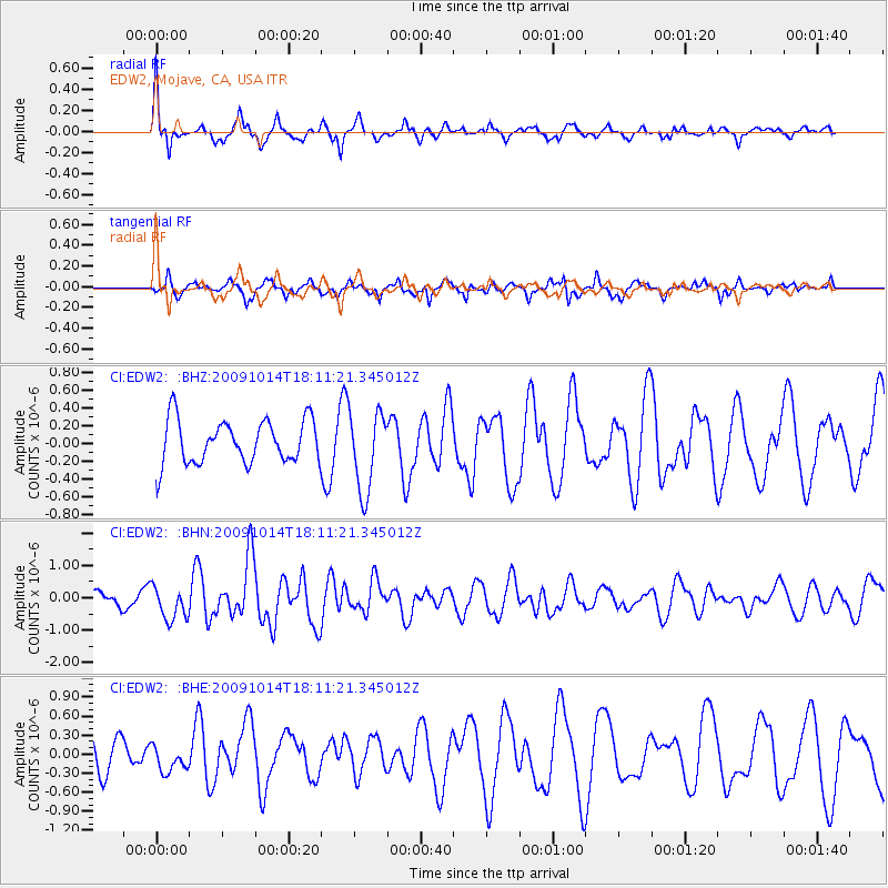
EDW2 EDW2, Mojave, CA, USA - Earthquake Result Viewer
*The percent match for this event was below the threshold and hence no stack was calculated.
| Earthquake location: |
Samoa Islands Region |
| Earthquake latitude/longitude: |
-14.9/-174.8 |
| Earthquake time(UTC): |
2009/10/14 (287) 18:00:21 GMT |
| Earthquake Depth: |
10 km |
| Earthquake Magnitude: |
5.7 MB, 6.0 MS, 6.3 MW, 6.2 MW |
| Earthquake Catalog/Contributor: |
WHDF/NEIC |
|
| Network: |
CI Caltech Regional Seismic Network |
| Station: |
EDW2 EDW2, Mojave, CA, USA |
| Lat/Lon: |
34.88 N/117.99 W |
| Elevation: |
772 m |
|
| Distance: |
73.2 deg |
| Az: |
45.964 deg |
| Baz: |
237.711 deg |
| Ray Param: |
$rayparam |
*The percent match for this event was below the threshold and hence was not used in the summary stack. |
|
| Radial Match: |
79.87349 % |
| Radial Bump: |
400 |
| Transverse Match: |
72.71898 % |
| Transverse Bump: |
325 |
| SOD ConfigId: |
2622 |
| Insert Time: |
2010-03-05 21:12:57.426 +0000 |
| GWidth: |
2.5 |
| Max Bumps: |
400 |
| Tol: |
0.001 |
|
Signal To Noise
| Channel | StoN | STA | LTA |
| CI:EDW2: :BHN:20091014T18:11:21.345012Z | 2.1541307 | 5.170106E-7 | 2.4000894E-7 |
| CI:EDW2: :BHE:20091014T18:11:21.345012Z | 0.8203699 | 2.223393E-7 | 2.7102323E-7 |
| CI:EDW2: :BHZ:20091014T18:11:21.345012Z | 1.8521166 | 4.516322E-7 | 2.4384653E-7 |
| Arrivals |
| Ps | |
| PpPs | |
| PsPs/PpSs | |


