You are here: Home > Network List > CN - Canadian National Seismograph Network Stations List
> Station PLBC Pleasant Camp, BC, CA > Earthquake Result Viewer
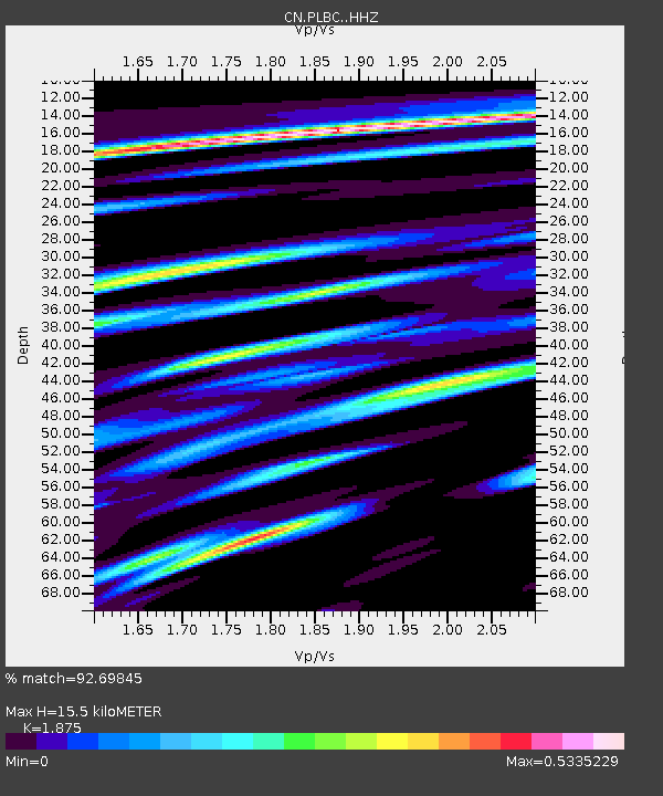
PLBC Pleasant Camp, BC, CA - Earthquake Result Viewer
| Earthquake location: |
South Of Fiji Islands |
| Earthquake latitude/longitude: |
-19.3/176.1 |
| Earthquake time(UTC): |
2017/01/03 (003) 21:52:31 GMT |
| Earthquake Depth: |
17 km |
| Earthquake Magnitude: |
6.9 Mww |
| Earthquake Catalog/Contributor: |
NEIC PDE/us |
|
| Network: |
CN Canadian National Seismograph Network |
| Station: |
PLBC Pleasant Camp, BC, CA |
| Lat/Lon: |
59.46 N/136.37 W |
| Elevation: |
279 m |
|
| Distance: |
87.6 deg |
| Az: |
22.172 deg |
| Baz: |
224.249 deg |
| Ray Param: |
0.043224853 |
| Estimated Moho Depth: |
15.5 km |
| Estimated Crust Vp/Vs: |
1.88 |
| Assumed Crust Vp: |
6.566 km/s |
| Estimated Crust Vs: |
3.502 km/s |
| Estimated Crust Poisson's Ratio: |
0.30 |
|
| Radial Match: |
92.69845 % |
| Radial Bump: |
330 |
| Transverse Match: |
73.13506 % |
| Transverse Bump: |
400 |
| SOD ConfigId: |
11737051 |
| Insert Time: |
2019-04-26 12:38:51.198 +0000 |
| GWidth: |
2.5 |
| Max Bumps: |
400 |
| Tol: |
0.001 |
|

Signal To Noise
| Channel | StoN | STA | LTA |
| CN:PLBC: :HHZ:20170103T22:04:47.040005Z | 22.117184 | 3.087613E-6 | 1.3960245E-7 |
| CN:PLBC: :HHN:20170103T22:04:47.040005Z | 5.604878 | 6.575655E-7 | 1.1732022E-7 |
| CN:PLBC: :HHE:20170103T22:04:47.040005Z | 7.541208 | 8.585068E-7 | 1.13842084E-7 |
| Arrivals |
| Ps | 2.1 SECOND |
| PpPs | 6.6 SECOND |
| PsPs/PpSs | 8.8 SECOND |


