You are here: Home > Network List > CN - Canadian National Seismograph Network Stations List
> Station YUK2 White River, YT, CA > Earthquake Result Viewer
YUK2 White River, YT, CA - Earthquake Result Viewer
| Earthquake location: |
South Of Fiji Islands |
| Earthquake latitude/longitude: |
-19.3/176.1 |
| Earthquake time(UTC): |
2017/01/03 (003) 21:52:31 GMT |
| Earthquake Depth: |
17 km |
| Earthquake Magnitude: |
6.9 Mww |
| Earthquake Catalog/Contributor: |
NEIC PDE/us |
|
| Network: |
CN Canadian National Seismograph Network |
| Station: |
YUK2 White River, YT, CA |
| Lat/Lon: |
61.77 N/140.84 W |
| Elevation: |
1229 m |
|
| Distance: |
87.8 deg |
| Az: |
18.977 deg |
| Baz: |
220.224 deg |
| Ray Param: |
0.043052223 |
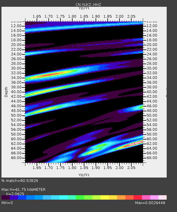
| Estimated Moho Depth: |
61.75 km |
| Estimated Crust Vp/Vs: |
2.06 |
| Assumed Crust Vp: |
6.566 km/s |
| Estimated Crust Vs: |
3.184 km/s |
| Estimated Crust Poisson's Ratio: |
0.35 |
|
| Radial Match: |
90.53928 % |
| Radial Bump: |
373 |
| Transverse Match: |
83.70587 % |
| Transverse Bump: |
400 |
| SOD ConfigId: |
11737051 |
| Insert Time: |
2019-04-26 12:38:59.667 +0000 |
| GWidth: |
2.5 |
| Max Bumps: |
400 |
| Tol: |
0.001 |
|

Signal To Noise
| Channel | StoN | STA | LTA |
| CN:YUK2: :HHZ:20170103T22:04:48.14999Z | 21.523138 | 4.0919185E-6 | 1.9011718E-7 |
| CN:YUK2: :HHN:20170103T22:04:48.14999Z | 8.019275 | 1.0194111E-6 | 1.271201E-7 |
| CN:YUK2: :HHE:20170103T22:04:48.14999Z | 6.6580954 | 7.804786E-7 | 1.172225E-7 |
| Arrivals |
| Ps | 10 SECOND |
| PpPs | 28 SECOND |
| PsPs/PpSs | 38 SECOND |


