You are here: Home > Network List > CI - Caltech Regional Seismic Network Stations List
> Station EDW2 EDW2, Mojave, CA, USA > Earthquake Result Viewer
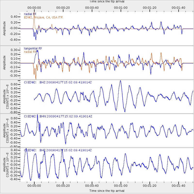
EDW2 EDW2, Mojave, CA, USA - Earthquake Result Viewer
*The percent match for this event was below the threshold and hence no stack was calculated.
| Earthquake location: |
Kuril Islands |
| Earthquake latitude/longitude: |
46.2/151.7 |
| Earthquake time(UTC): |
2009/04/17 (107) 14:51:58 GMT |
| Earthquake Depth: |
49 km |
| Earthquake Magnitude: |
5.5 MB, 5.0 MS, 5.7 MW, 5.6 MW |
| Earthquake Catalog/Contributor: |
WHDF/NEIC |
|
| Network: |
CI Caltech Regional Seismic Network |
| Station: |
EDW2 EDW2, Mojave, CA, USA |
| Lat/Lon: |
34.88 N/117.99 W |
| Elevation: |
772 m |
|
| Distance: |
66.0 deg |
| Az: |
64.125 deg |
| Baz: |
310.485 deg |
| Ray Param: |
$rayparam |
*The percent match for this event was below the threshold and hence was not used in the summary stack. |
|
| Radial Match: |
34.800026 % |
| Radial Bump: |
350 |
| Transverse Match: |
70.21796 % |
| Transverse Bump: |
376 |
| SOD ConfigId: |
2658 |
| Insert Time: |
2010-03-05 21:13:11.133 +0000 |
| GWidth: |
2.5 |
| Max Bumps: |
400 |
| Tol: |
0.001 |
|
Signal To Noise
| Channel | StoN | STA | LTA |
| CI:EDW2: :BHN:20090417T15:02:09.419014Z | 1.9348732 | 3.388317E-7 | 1.751183E-7 |
| CI:EDW2: :BHE:20090417T15:02:09.419014Z | 1.3302349 | 2.3318474E-7 | 1.7529591E-7 |
| CI:EDW2: :BHZ:20090417T15:02:09.419014Z | 0.89874864 | 1.6743024E-7 | 1.8629264E-7 |
| Arrivals |
| Ps | |
| PpPs | |
| PsPs/PpSs | |


