You are here: Home > Network List > NN - Western Great Basin/Eastern Sierra Nevada Stations List
> Station BEK Beckworth, California w84 > Earthquake Result Viewer
BEK Beckworth, California w84 - Earthquake Result Viewer
| Earthquake location: |
South Of Fiji Islands |
| Earthquake latitude/longitude: |
-19.3/176.1 |
| Earthquake time(UTC): |
2017/01/03 (003) 21:52:31 GMT |
| Earthquake Depth: |
17 km |
| Earthquake Magnitude: |
6.9 Mww |
| Earthquake Catalog/Contributor: |
NEIC PDE/us |
|
| Network: |
NN Western Great Basin/Eastern Sierra Nevada |
| Station: |
BEK Beckworth, California w84 |
| Lat/Lon: |
39.87 N/120.36 W |
| Elevation: |
1743 m |
|
| Distance: |
83.5 deg |
| Az: |
43.93 deg |
| Baz: |
238.348 deg |
| Ray Param: |
0.046134368 |
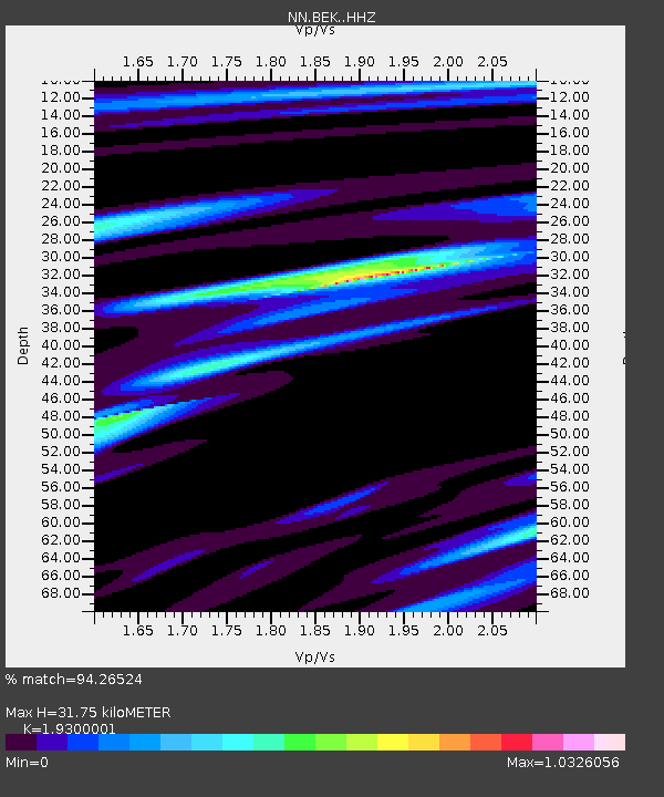
| Estimated Moho Depth: |
31.75 km |
| Estimated Crust Vp/Vs: |
1.93 |
| Assumed Crust Vp: |
6.597 km/s |
| Estimated Crust Vs: |
3.418 km/s |
| Estimated Crust Poisson's Ratio: |
0.32 |
|
| Radial Match: |
94.26524 % |
| Radial Bump: |
400 |
| Transverse Match: |
84.972275 % |
| Transverse Bump: |
400 |
| SOD ConfigId: |
11737051 |
| Insert Time: |
2019-04-26 12:40:22.812 +0000 |
| GWidth: |
2.5 |
| Max Bumps: |
400 |
| Tol: |
0.001 |
|

Signal To Noise
| Channel | StoN | STA | LTA |
| NN:BEK: :HHZ:20170103T22:04:26.834988Z | 15.888652 | 3.6448619E-6 | 2.2940031E-7 |
| NN:BEK: :HHN:20170103T22:04:26.834988Z | 4.4768567 | 5.7207984E-7 | 1.2778605E-7 |
| NN:BEK: :HHE:20170103T22:04:26.834988Z | 6.2406435 | 1.0790322E-6 | 1.72904E-7 |
| Arrivals |
| Ps | 4.6 SECOND |
| PpPs | 14 SECOND |
| PsPs/PpSs | 18 SECOND |


