You are here: Home > Network List > NN - Western Great Basin/Eastern Sierra Nevada Stations List
> Station SHP Sheep Range, Nevada w84gm > Earthquake Result Viewer
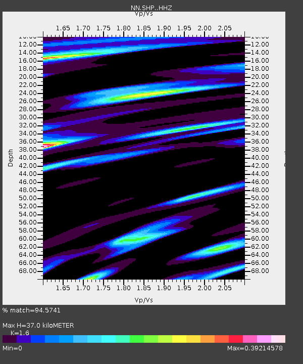
SHP Sheep Range, Nevada w84gm - Earthquake Result Viewer
| Earthquake location: |
South Of Fiji Islands |
| Earthquake latitude/longitude: |
-19.3/176.1 |
| Earthquake time(UTC): |
2017/01/03 (003) 21:52:31 GMT |
| Earthquake Depth: |
17 km |
| Earthquake Magnitude: |
6.9 Mww |
| Earthquake Catalog/Contributor: |
NEIC PDE/us |
|
| Network: |
NN Western Great Basin/Eastern Sierra Nevada |
| Station: |
SHP Sheep Range, Nevada w84gm |
| Lat/Lon: |
36.50 N/115.16 W |
| Elevation: |
1632 m |
|
| Distance: |
85.4 deg |
| Az: |
48.901 deg |
| Baz: |
242.036 deg |
| Ray Param: |
0.044788063 |
| Estimated Moho Depth: |
37.0 km |
| Estimated Crust Vp/Vs: |
1.60 |
| Assumed Crust Vp: |
6.276 km/s |
| Estimated Crust Vs: |
3.922 km/s |
| Estimated Crust Poisson's Ratio: |
0.18 |
|
| Radial Match: |
94.5741 % |
| Radial Bump: |
388 |
| Transverse Match: |
82.05961 % |
| Transverse Bump: |
400 |
| SOD ConfigId: |
11737051 |
| Insert Time: |
2019-04-26 12:40:39.076 +0000 |
| GWidth: |
2.5 |
| Max Bumps: |
400 |
| Tol: |
0.001 |
|

Signal To Noise
| Channel | StoN | STA | LTA |
| NN:SHP: :HHZ:20170103T22:04:36.365017Z | 10.010177 | 1.0733853E-6 | 1.0722941E-7 |
| NN:SHP: :HHN:20170103T22:04:36.365017Z | 1.7796043 | 1.6673599E-7 | 9.369273E-8 |
| NN:SHP: :HHE:20170103T22:04:36.365017Z | 3.1784472 | 3.1580979E-7 | 9.935977E-8 |
| Arrivals |
| Ps | 3.6 SECOND |
| PpPs | 15 SECOND |
| PsPs/PpSs | 19 SECOND |


