You are here: Home > Network List > NY - Yukon Northwest Seismic Network(YNSN) Stations List
> Station MAYO Mayo, Yukon, CANADA > Earthquake Result Viewer
MAYO Mayo, Yukon, CANADA - Earthquake Result Viewer
| Earthquake location: |
South Of Fiji Islands |
| Earthquake latitude/longitude: |
-19.3/176.1 |
| Earthquake time(UTC): |
2017/01/03 (003) 21:52:31 GMT |
| Earthquake Depth: |
17 km |
| Earthquake Magnitude: |
6.9 Mww |
| Earthquake Catalog/Contributor: |
NEIC PDE/us |
|
| Network: |
NY Yukon Northwest Seismic Network(YNSN) |
| Station: |
MAYO Mayo, Yukon, CANADA |
| Lat/Lon: |
63.60 N/135.89 W |
| Elevation: |
0.0 m |
|
| Distance: |
90.7 deg |
| Az: |
19.425 deg |
| Baz: |
224.623 deg |
| Ray Param: |
0.041654274 |
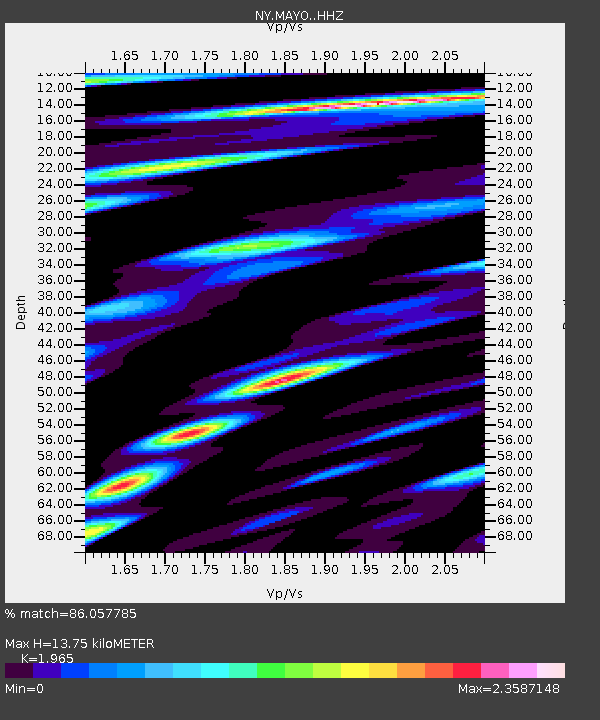
| Estimated Moho Depth: |
13.75 km |
| Estimated Crust Vp/Vs: |
1.97 |
| Assumed Crust Vp: |
6.419 km/s |
| Estimated Crust Vs: |
3.267 km/s |
| Estimated Crust Poisson's Ratio: |
0.33 |
|
| Radial Match: |
86.057785 % |
| Radial Bump: |
400 |
| Transverse Match: |
60.600697 % |
| Transverse Bump: |
400 |
| SOD ConfigId: |
11737051 |
| Insert Time: |
2019-04-26 12:40:52.361 +0000 |
| GWidth: |
2.5 |
| Max Bumps: |
400 |
| Tol: |
0.001 |
|

Signal To Noise
| Channel | StoN | STA | LTA |
| NY:MAYO: :HHZ:20170103T22:05:01.690029Z | 20.387682 | 3.295447E-6 | 1.6163911E-7 |
| NY:MAYO: :HHN:20170103T22:05:01.690029Z | 5.2246656 | 1.0557891E-6 | 2.0207783E-7 |
| NY:MAYO: :HHE:20170103T22:05:01.690029Z | 6.604264 | 1.1824984E-6 | 1.7905076E-7 |
| Arrivals |
| Ps | 2.1 SECOND |
| PpPs | 6.2 SECOND |
| PsPs/PpSs | 8.3 SECOND |


