You are here: Home > Network List > PY - PFO Array Stations List
> Station BPH08 Pinon Flat Observatory, CA, USA > Earthquake Result Viewer
BPH08 Pinon Flat Observatory, CA, USA - Earthquake Result Viewer
| Earthquake location: |
South Of Fiji Islands |
| Earthquake latitude/longitude: |
-19.3/176.1 |
| Earthquake time(UTC): |
2017/01/03 (003) 21:52:31 GMT |
| Earthquake Depth: |
17 km |
| Earthquake Magnitude: |
6.9 Mww |
| Earthquake Catalog/Contributor: |
NEIC PDE/us |
|
| Network: |
PY PFO Array |
| Station: |
BPH08 Pinon Flat Observatory, CA, USA |
| Lat/Lon: |
33.61 N/116.46 W |
| Elevation: |
1300 m |
|
| Distance: |
83.1 deg |
| Az: |
50.95 deg |
| Baz: |
241.497 deg |
| Ray Param: |
0.046428084 |
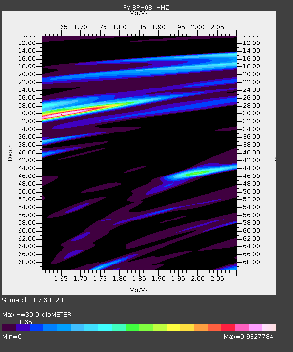
| Estimated Moho Depth: |
30.0 km |
| Estimated Crust Vp/Vs: |
1.65 |
| Assumed Crust Vp: |
6.264 km/s |
| Estimated Crust Vs: |
3.796 km/s |
| Estimated Crust Poisson's Ratio: |
0.21 |
|
| Radial Match: |
87.68128 % |
| Radial Bump: |
400 |
| Transverse Match: |
83.22609 % |
| Transverse Bump: |
400 |
| SOD ConfigId: |
11737051 |
| Insert Time: |
2019-04-26 12:41:18.365 +0000 |
| GWidth: |
2.5 |
| Max Bumps: |
400 |
| Tol: |
0.001 |
|

Signal To Noise
| Channel | StoN | STA | LTA |
| PY:BPH08: :HHZ:20170103T22:04:24.685024Z | 14.81172 | 2.7086448E-6 | 1.8287172E-7 |
| PY:BPH08: :HHN:20170103T22:04:24.685024Z | 1.6336966 | 2.9521712E-7 | 1.8070499E-7 |
| PY:BPH08: :HHE:20170103T22:04:24.685024Z | 6.4414277 | 7.342816E-7 | 1.1399362E-7 |
| Arrivals |
| Ps | 3.2 SECOND |
| PpPs | 12 SECOND |
| PsPs/PpSs | 16 SECOND |


