You are here: Home > Network List > RV - Regional Alberta Seismic Observatory for Earthquake Studies Network Stations List
> Station BRLDA Berland Lookout Tower, AB > Earthquake Result Viewer
BRLDA Berland Lookout Tower, AB - Earthquake Result Viewer
| Earthquake location: |
South Of Fiji Islands |
| Earthquake latitude/longitude: |
-19.3/176.1 |
| Earthquake time(UTC): |
2017/01/03 (003) 21:52:31 GMT |
| Earthquake Depth: |
17 km |
| Earthquake Magnitude: |
6.9 Mww |
| Earthquake Catalog/Contributor: |
NEIC PDE/us |
|
| Network: |
RV Regional Alberta Seismic Observatory for Earthquake Studies Network |
| Station: |
BRLDA Berland Lookout Tower, AB |
| Lat/Lon: |
54.09 N/117.40 W |
| Elevation: |
1224 m |
|
| Distance: |
92.5 deg |
| Az: |
32.747 deg |
| Baz: |
240.131 deg |
| Ray Param: |
0.041434158 |
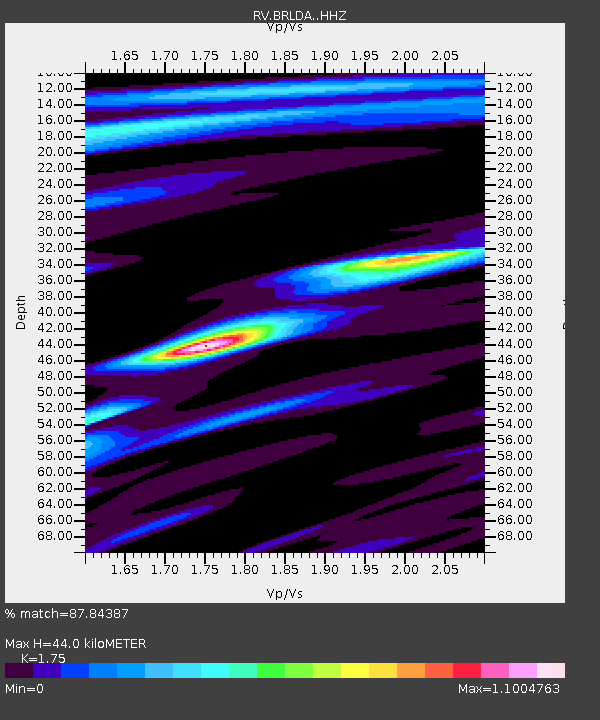
| Estimated Moho Depth: |
44.0 km |
| Estimated Crust Vp/Vs: |
1.75 |
| Assumed Crust Vp: |
6.426 km/s |
| Estimated Crust Vs: |
3.672 km/s |
| Estimated Crust Poisson's Ratio: |
0.26 |
|
| Radial Match: |
87.84387 % |
| Radial Bump: |
400 |
| Transverse Match: |
67.10656 % |
| Transverse Bump: |
384 |
| SOD ConfigId: |
11737051 |
| Insert Time: |
2019-04-26 12:42:06.640 +0000 |
| GWidth: |
2.5 |
| Max Bumps: |
400 |
| Tol: |
0.001 |
|

Signal To Noise
| Channel | StoN | STA | LTA |
| RV:BRLDA: :HHZ:20170103T22:05:10.230007Z | 8.28565 | 3.8636094E-6 | 4.6630132E-7 |
| RV:BRLDA: :HHN:20170103T22:05:10.230007Z | 1.3473495 | 6.967795E-7 | 5.171483E-7 |
| RV:BRLDA: :HHE:20170103T22:05:10.230007Z | 2.1138678 | 9.885284E-7 | 4.6763967E-7 |
| Arrivals |
| Ps | 5.2 SECOND |
| PpPs | 18 SECOND |
| PsPs/PpSs | 24 SECOND |


