You are here: Home > Network List > RV - Regional Alberta Seismic Observatory for Earthquake Studies Network Stations List
> Station HILA High Level, AB > Earthquake Result Viewer
HILA High Level, AB - Earthquake Result Viewer
| Earthquake location: |
South Of Fiji Islands |
| Earthquake latitude/longitude: |
-19.3/176.1 |
| Earthquake time(UTC): |
2017/01/03 (003) 21:52:31 GMT |
| Earthquake Depth: |
17 km |
| Earthquake Magnitude: |
6.9 Mww |
| Earthquake Catalog/Contributor: |
NEIC PDE/us |
|
| Network: |
RV Regional Alberta Seismic Observatory for Earthquake Studies Network |
| Station: |
HILA High Level, AB |
| Lat/Lon: |
58.56 N/117.02 W |
| Elevation: |
329 m |
|
| Distance: |
94.9 deg |
| Az: |
28.952 deg |
| Baz: |
240.697 deg |
| Ray Param: |
0.04091008 |
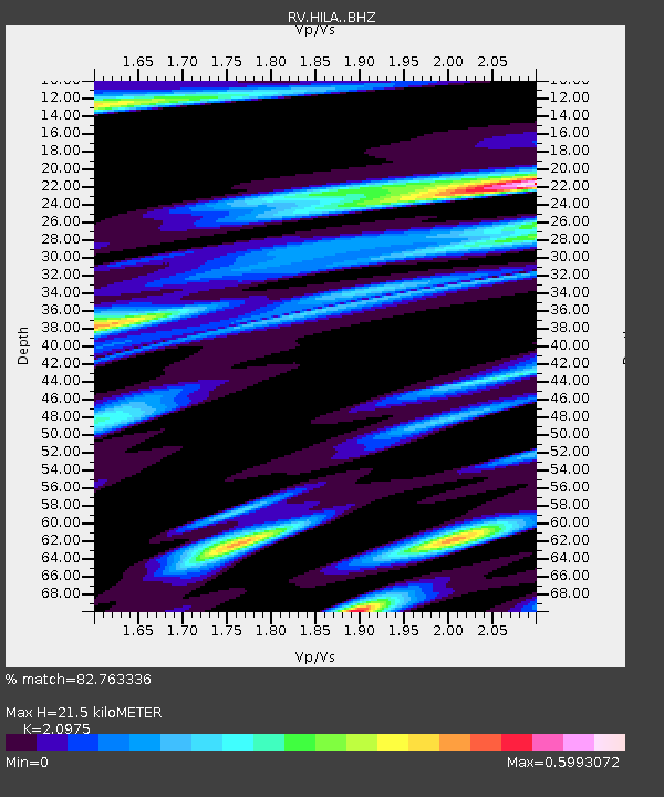
| Estimated Moho Depth: |
21.5 km |
| Estimated Crust Vp/Vs: |
2.10 |
| Assumed Crust Vp: |
6.498 km/s |
| Estimated Crust Vs: |
3.098 km/s |
| Estimated Crust Poisson's Ratio: |
0.35 |
|
| Radial Match: |
82.763336 % |
| Radial Bump: |
400 |
| Transverse Match: |
64.87791 % |
| Transverse Bump: |
400 |
| SOD ConfigId: |
11737051 |
| Insert Time: |
2019-04-26 12:42:07.554 +0000 |
| GWidth: |
2.5 |
| Max Bumps: |
400 |
| Tol: |
0.001 |
|

Signal To Noise
| Channel | StoN | STA | LTA |
| RV:HILA: :BHZ:20170103T22:05:21.199978Z | 14.36697 | 3.955689E-5 | 2.7533215E-6 |
| RV:HILA: :BHN:20170103T22:05:21.199978Z | 2.2409492 | 1.3800263E-5 | 6.1582223E-6 |
| RV:HILA: :BHE:20170103T22:05:21.199978Z | 2.1170228 | 1.030339E-5 | 4.8669244E-6 |
| Arrivals |
| Ps | 3.7 SECOND |
| PpPs | 10 SECOND |
| PsPs/PpSs | 14 SECOND |


