You are here: Home > Network List > TA - USArray Transportable Network (new EarthScope stations) Stations List
> Station E25K Arctic Village, AK, USA > Earthquake Result Viewer
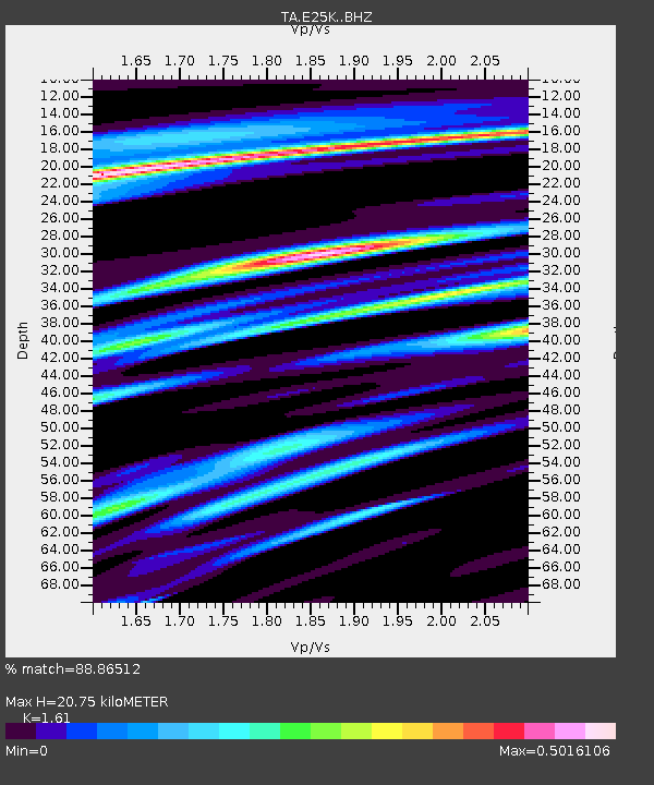
E25K Arctic Village, AK, USA - Earthquake Result Viewer
| Earthquake location: |
South Of Fiji Islands |
| Earthquake latitude/longitude: |
-19.3/176.1 |
| Earthquake time(UTC): |
2017/01/03 (003) 21:52:31 GMT |
| Earthquake Depth: |
17 km |
| Earthquake Magnitude: |
6.9 Mww |
| Earthquake Catalog/Contributor: |
NEIC PDE/us |
|
| Network: |
TA USArray Transportable Network (new EarthScope stations) |
| Station: |
E25K Arctic Village, AK, USA |
| Lat/Lon: |
68.12 N/145.57 W |
| Elevation: |
652 m |
|
| Distance: |
91.6 deg |
| Az: |
13.462 deg |
| Baz: |
215.911 deg |
| Ray Param: |
0.04158631 |
| Estimated Moho Depth: |
20.75 km |
| Estimated Crust Vp/Vs: |
1.61 |
| Assumed Crust Vp: |
6.455 km/s |
| Estimated Crust Vs: |
4.009 km/s |
| Estimated Crust Poisson's Ratio: |
0.19 |
|
| Radial Match: |
88.86512 % |
| Radial Bump: |
400 |
| Transverse Match: |
79.11132 % |
| Transverse Bump: |
400 |
| SOD ConfigId: |
11737051 |
| Insert Time: |
2019-04-26 12:42:31.616 +0000 |
| GWidth: |
2.5 |
| Max Bumps: |
400 |
| Tol: |
0.001 |
|

Signal To Noise
| Channel | StoN | STA | LTA |
| TA:E25K: :BHZ:20170103T22:05:05.798977Z | 14.632556 | 1.9836841E-6 | 1.3556648E-7 |
| TA:E25K: :BHN:20170103T22:05:05.798977Z | 5.5832076 | 5.157238E-7 | 9.237051E-8 |
| TA:E25K: :BHE:20170103T22:05:05.798977Z | 3.0333219 | 3.4603505E-7 | 1.1407791E-7 |
| Arrivals |
| Ps | 2.0 SECOND |
| PpPs | 8.2 SECOND |
| PsPs/PpSs | 10 SECOND |


