You are here: Home > Network List > TA - USArray Transportable Network (new EarthScope stations) Stations List
> Station G24K Hadweenzic River, AK, USA > Earthquake Result Viewer
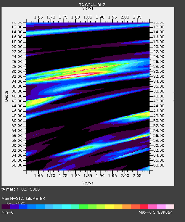
G24K Hadweenzic River, AK, USA - Earthquake Result Viewer
| Earthquake location: |
South Of Fiji Islands |
| Earthquake latitude/longitude: |
-19.3/176.1 |
| Earthquake time(UTC): |
2017/01/03 (003) 21:52:31 GMT |
| Earthquake Depth: |
17 km |
| Earthquake Magnitude: |
6.9 Mww |
| Earthquake Catalog/Contributor: |
NEIC PDE/us |
|
| Network: |
TA USArray Transportable Network (new EarthScope stations) |
| Station: |
G24K Hadweenzic River, AK, USA |
| Lat/Lon: |
66.70 N/147.48 W |
| Elevation: |
503 m |
|
| Distance: |
90.0 deg |
| Az: |
13.677 deg |
| Baz: |
214.149 deg |
| Ray Param: |
0.041704517 |
| Estimated Moho Depth: |
31.5 km |
| Estimated Crust Vp/Vs: |
1.79 |
| Assumed Crust Vp: |
6.522 km/s |
| Estimated Crust Vs: |
3.638 km/s |
| Estimated Crust Poisson's Ratio: |
0.27 |
|
| Radial Match: |
82.75006 % |
| Radial Bump: |
400 |
| Transverse Match: |
71.61497 % |
| Transverse Bump: |
400 |
| SOD ConfigId: |
11737051 |
| Insert Time: |
2019-04-26 12:42:38.778 +0000 |
| GWidth: |
2.5 |
| Max Bumps: |
400 |
| Tol: |
0.001 |
|

Signal To Noise
| Channel | StoN | STA | LTA |
| TA:G24K: :BHZ:20170103T22:04:58.449978Z | 14.995935 | 2.2514118E-6 | 1.501348E-7 |
| TA:G24K: :BHN:20170103T22:04:58.449978Z | 6.0401654 | 7.226471E-7 | 1.1964028E-7 |
| TA:G24K: :BHE:20170103T22:04:58.449978Z | 3.4420197 | 4.3011755E-7 | 1.249608E-7 |
| Arrivals |
| Ps | 3.9 SECOND |
| PpPs | 13 SECOND |
| PsPs/PpSs | 17 SECOND |


