You are here: Home > Network List > CI - Caltech Regional Seismic Network Stations List
> Station EDW2 EDW2, Mojave, CA, USA > Earthquake Result Viewer
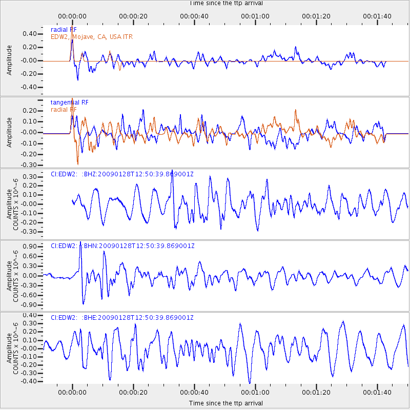
EDW2 EDW2, Mojave, CA, USA - Earthquake Result Viewer
*The percent match for this event was below the threshold and hence no stack was calculated.
| Earthquake location: |
Samoa Islands Region |
| Earthquake latitude/longitude: |
-17.0/-172.1 |
| Earthquake time(UTC): |
2009/01/28 (028) 12:39:42 GMT |
| Earthquake Depth: |
10 km |
| Earthquake Magnitude: |
5.6 MB, 5.3 MS, 5.5 MW |
| Earthquake Catalog/Contributor: |
WHDF/NEIC |
|
| Network: |
CI Caltech Regional Seismic Network |
| Station: |
EDW2 EDW2, Mojave, CA, USA |
| Lat/Lon: |
34.88 N/117.99 W |
| Elevation: |
772 m |
|
| Distance: |
72.8 deg |
| Az: |
44.194 deg |
| Baz: |
234.235 deg |
| Ray Param: |
$rayparam |
*The percent match for this event was below the threshold and hence was not used in the summary stack. |
|
| Radial Match: |
68.03693 % |
| Radial Bump: |
400 |
| Transverse Match: |
66.682884 % |
| Transverse Bump: |
400 |
| SOD ConfigId: |
2658 |
| Insert Time: |
2010-03-05 21:13:59.360 +0000 |
| GWidth: |
2.5 |
| Max Bumps: |
400 |
| Tol: |
0.001 |
|
Signal To Noise
| Channel | StoN | STA | LTA |
| CI:EDW2: :BHN:20090128T12:50:39.869001Z | 4.4890985 | 4.5277855E-7 | 1.008618E-7 |
| CI:EDW2: :BHE:20090128T12:50:39.869001Z | 1.3918253 | 1.6128693E-7 | 1.1588159E-7 |
| CI:EDW2: :BHZ:20090128T12:50:39.869001Z | 1.5275507 | 1.6840924E-7 | 1.10247896E-7 |
| Arrivals |
| Ps | |
| PpPs | |
| PsPs/PpSs | |


