You are here: Home > Network List > TA - USArray Transportable Network (new EarthScope stations) Stations List
> Station O28M Mount Upton, YT, CAN > Earthquake Result Viewer
O28M Mount Upton, YT, CAN - Earthquake Result Viewer
| Earthquake location: |
South Of Fiji Islands |
| Earthquake latitude/longitude: |
-19.3/176.1 |
| Earthquake time(UTC): |
2017/01/03 (003) 21:52:31 GMT |
| Earthquake Depth: |
17 km |
| Earthquake Magnitude: |
6.9 Mww |
| Earthquake Catalog/Contributor: |
NEIC PDE/us |
|
| Network: |
TA USArray Transportable Network (new EarthScope stations) |
| Station: |
O28M Mount Upton, YT, CAN |
| Lat/Lon: |
60.77 N/140.19 W |
| Elevation: |
2622 m |
|
| Distance: |
87.2 deg |
| Az: |
19.866 deg |
| Baz: |
220.834 deg |
| Ray Param: |
0.043452553 |
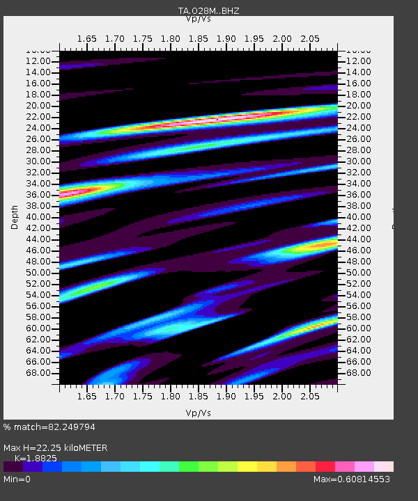
| Estimated Moho Depth: |
22.25 km |
| Estimated Crust Vp/Vs: |
1.88 |
| Assumed Crust Vp: |
6.566 km/s |
| Estimated Crust Vs: |
3.488 km/s |
| Estimated Crust Poisson's Ratio: |
0.30 |
|
| Radial Match: |
82.249794 % |
| Radial Bump: |
400 |
| Transverse Match: |
80.454056 % |
| Transverse Bump: |
400 |
| SOD ConfigId: |
11737051 |
| Insert Time: |
2019-04-26 12:43:22.489 +0000 |
| GWidth: |
2.5 |
| Max Bumps: |
400 |
| Tol: |
0.001 |
|

Signal To Noise
| Channel | StoN | STA | LTA |
| TA:O28M: :BHZ:20170103T22:04:45.500027Z | 20.423918 | 3.6116828E-6 | 1.7683594E-7 |
| TA:O28M: :BHN:20170103T22:04:45.500027Z | 7.180783 | 1.135242E-6 | 1.5809447E-7 |
| TA:O28M: :BHE:20170103T22:04:45.500027Z | 6.4622107 | 1.0100302E-6 | 1.5629794E-7 |
| Arrivals |
| Ps | 3.1 SECOND |
| PpPs | 9.6 SECOND |
| PsPs/PpSs | 13 SECOND |


