You are here: Home > Network List > TA - USArray Transportable Network (new EarthScope stations) Stations List
> Station P23K Montague Island, AK, USA > Earthquake Result Viewer
P23K Montague Island, AK, USA - Earthquake Result Viewer
| Earthquake location: |
South Of Fiji Islands |
| Earthquake latitude/longitude: |
-19.3/176.1 |
| Earthquake time(UTC): |
2017/01/03 (003) 21:52:31 GMT |
| Earthquake Depth: |
17 km |
| Earthquake Magnitude: |
6.9 Mww |
| Earthquake Catalog/Contributor: |
NEIC PDE/us |
|
| Network: |
TA USArray Transportable Network (new EarthScope stations) |
| Station: |
P23K Montague Island, AK, USA |
| Lat/Lon: |
60.00 N/147.40 W |
| Elevation: |
287 m |
|
| Distance: |
84.4 deg |
| Az: |
17.497 deg |
| Baz: |
214.4 deg |
| Ray Param: |
0.045468472 |
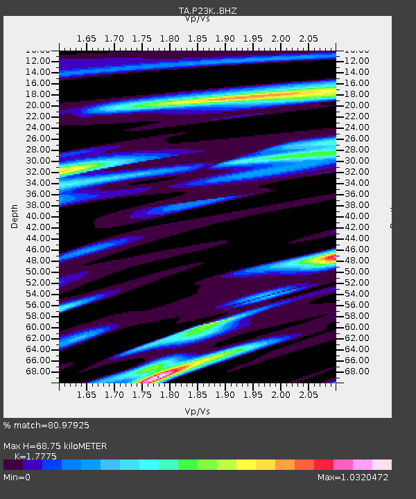
| Estimated Moho Depth: |
68.75 km |
| Estimated Crust Vp/Vs: |
1.78 |
| Assumed Crust Vp: |
5.989 km/s |
| Estimated Crust Vs: |
3.369 km/s |
| Estimated Crust Poisson's Ratio: |
0.27 |
|
| Radial Match: |
80.97925 % |
| Radial Bump: |
400 |
| Transverse Match: |
81.66873 % |
| Transverse Bump: |
400 |
| SOD ConfigId: |
11737051 |
| Insert Time: |
2019-04-26 12:43:27.728 +0000 |
| GWidth: |
2.5 |
| Max Bumps: |
400 |
| Tol: |
0.001 |
|

Signal To Noise
| Channel | StoN | STA | LTA |
| TA:P23K: :BHZ:20170103T22:04:31.675015Z | 14.531443 | 5.9705667E-6 | 4.1087227E-7 |
| TA:P23K: :BHN:20170103T22:04:31.675015Z | 4.3048224 | 1.9526472E-6 | 4.5359528E-7 |
| TA:P23K: :BHE:20170103T22:04:31.675015Z | 1.2567662 | 8.024369E-7 | 6.3849336E-7 |
| Arrivals |
| Ps | 9.1 SECOND |
| PpPs | 31 SECOND |
| PsPs/PpSs | 40 SECOND |


