You are here: Home > Network List > TA - USArray Transportable Network (new EarthScope stations) Stations List
> Station Q23K Middleton Island, AK, USA > Earthquake Result Viewer
Q23K Middleton Island, AK, USA - Earthquake Result Viewer
| Earthquake location: |
South Of Fiji Islands |
| Earthquake latitude/longitude: |
-19.3/176.1 |
| Earthquake time(UTC): |
2017/01/03 (003) 21:52:31 GMT |
| Earthquake Depth: |
17 km |
| Earthquake Magnitude: |
6.9 Mww |
| Earthquake Catalog/Contributor: |
NEIC PDE/us |
|
| Network: |
TA USArray Transportable Network (new EarthScope stations) |
| Station: |
Q23K Middleton Island, AK, USA |
| Lat/Lon: |
59.43 N/146.35 W |
| Elevation: |
46 m |
|
| Distance: |
84.3 deg |
| Az: |
18.265 deg |
| Baz: |
215.383 deg |
| Ray Param: |
0.04558434 |
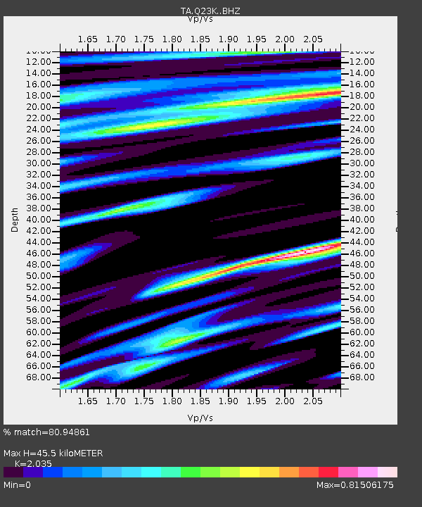
| Estimated Moho Depth: |
45.5 km |
| Estimated Crust Vp/Vs: |
2.04 |
| Assumed Crust Vp: |
5.989 km/s |
| Estimated Crust Vs: |
2.943 km/s |
| Estimated Crust Poisson's Ratio: |
0.34 |
|
| Radial Match: |
80.94861 % |
| Radial Bump: |
400 |
| Transverse Match: |
79.524284 % |
| Transverse Bump: |
400 |
| SOD ConfigId: |
11737051 |
| Insert Time: |
2019-04-26 12:43:34.080 +0000 |
| GWidth: |
2.5 |
| Max Bumps: |
400 |
| Tol: |
0.001 |
|

Signal To Noise
| Channel | StoN | STA | LTA |
| TA:Q23K: :BHZ:20170103T22:04:30.875027Z | 4.8507648 | 6.25805E-6 | 1.2901161E-6 |
| TA:Q23K: :BHN:20170103T22:04:30.875027Z | 1.1957476 | 1.6730185E-6 | 1.3991402E-6 |
| TA:Q23K: :BHE:20170103T22:04:30.875027Z | 0.8215538 | 1.3386671E-6 | 1.6294332E-6 |
| Arrivals |
| Ps | 8.0 SECOND |
| PpPs | 23 SECOND |
| PsPs/PpSs | 31 SECOND |


