You are here: Home > Network List > TA - USArray Transportable Network (new EarthScope stations) Stations List
> Station S31K Pelican, AK, USA > Earthquake Result Viewer
S31K Pelican, AK, USA - Earthquake Result Viewer
| Earthquake location: |
South Of Fiji Islands |
| Earthquake latitude/longitude: |
-19.3/176.1 |
| Earthquake time(UTC): |
2017/01/03 (003) 21:52:31 GMT |
| Earthquake Depth: |
17 km |
| Earthquake Magnitude: |
6.9 Mww |
| Earthquake Catalog/Contributor: |
NEIC PDE/us |
|
| Network: |
TA USArray Transportable Network (new EarthScope stations) |
| Station: |
S31K Pelican, AK, USA |
| Lat/Lon: |
57.96 N/136.23 W |
| Elevation: |
34 m |
|
| Distance: |
86.5 deg |
| Az: |
23.271 deg |
| Baz: |
224.42 deg |
| Ray Param: |
0.043965947 |
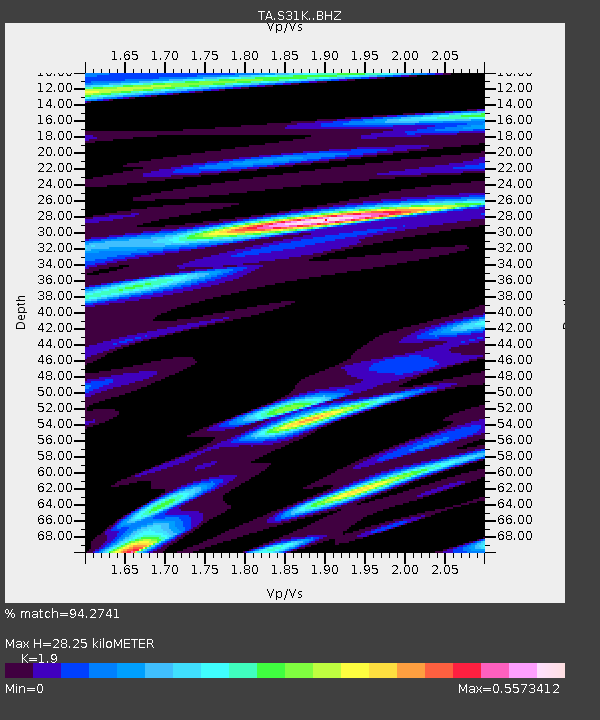
| Estimated Moho Depth: |
28.25 km |
| Estimated Crust Vp/Vs: |
1.90 |
| Assumed Crust Vp: |
6.134 km/s |
| Estimated Crust Vs: |
3.228 km/s |
| Estimated Crust Poisson's Ratio: |
0.31 |
|
| Radial Match: |
94.2741 % |
| Radial Bump: |
400 |
| Transverse Match: |
88.49574 % |
| Transverse Bump: |
400 |
| SOD ConfigId: |
11737051 |
| Insert Time: |
2019-04-26 12:43:43.185 +0000 |
| GWidth: |
2.5 |
| Max Bumps: |
400 |
| Tol: |
0.001 |
|

Signal To Noise
| Channel | StoN | STA | LTA |
| TA:S31K: :BHZ:20170103T22:04:42.100002Z | 22.468996 | 4.432326E-6 | 1.972641E-7 |
| TA:S31K: :BHN:20170103T22:04:42.100002Z | 6.2815795 | 1.1716826E-6 | 1.8652673E-7 |
| TA:S31K: :BHE:20170103T22:04:42.100002Z | 6.801003 | 1.0909815E-6 | 1.604148E-7 |
| Arrivals |
| Ps | 4.2 SECOND |
| PpPs | 13 SECOND |
| PsPs/PpSs | 17 SECOND |


