You are here: Home > Network List > TX - Texas Seismological Network Stations List
> Station FW03 Perrin-Whitt Elementary School > Earthquake Result Viewer
FW03 Perrin-Whitt Elementary School - Earthquake Result Viewer
| Earthquake location: |
South Of Fiji Islands |
| Earthquake latitude/longitude: |
-19.3/176.1 |
| Earthquake time(UTC): |
2017/01/03 (003) 21:52:31 GMT |
| Earthquake Depth: |
17 km |
| Earthquake Magnitude: |
6.9 Mww |
| Earthquake Catalog/Contributor: |
NEIC PDE/us |
|
| Network: |
TX Texas Seismological Network |
| Station: |
FW03 Perrin-Whitt Elementary School |
| Lat/Lon: |
33.04 N/98.07 W |
| Elevation: |
322 m |
|
| Distance: |
97.0 deg |
| Az: |
57.57 deg |
| Baz: |
251.612 deg |
| Ray Param: |
0.04034717 |
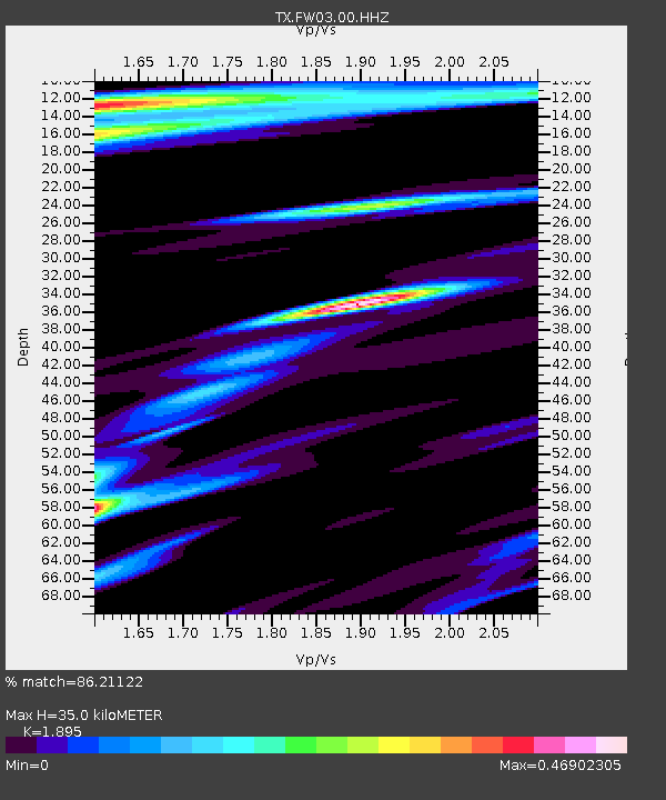
| Estimated Moho Depth: |
35.0 km |
| Estimated Crust Vp/Vs: |
1.89 |
| Assumed Crust Vp: |
6.426 km/s |
| Estimated Crust Vs: |
3.391 km/s |
| Estimated Crust Poisson's Ratio: |
0.31 |
|
| Radial Match: |
86.21122 % |
| Radial Bump: |
339 |
| Transverse Match: |
54.819008 % |
| Transverse Bump: |
389 |
| SOD ConfigId: |
11737051 |
| Insert Time: |
2019-04-26 12:44:07.740 +0000 |
| GWidth: |
2.5 |
| Max Bumps: |
400 |
| Tol: |
0.001 |
|

Signal To Noise
| Channel | StoN | STA | LTA |
| TX:FW03:00:HHZ:20170103T22:05:30.339993Z | 4.018974 | 9.812586E-7 | 2.441565E-7 |
| TX:FW03:00:HH1:20170103T22:05:30.339993Z | 0.98267853 | 3.6852492E-7 | 3.7502082E-7 |
| TX:FW03:00:HH2:20170103T22:05:30.339993Z | 1.5060083 | 3.88072E-7 | 2.5768253E-7 |
| Arrivals |
| Ps | 5.0 SECOND |
| PpPs | 15 SECOND |
| PsPs/PpSs | 20 SECOND |


