You are here: Home > Network List > UW - Pacific Northwest Regional Seismic Network Stations List
> Station LTY Liberty (broad-band) > Earthquake Result Viewer
LTY Liberty (broad-band) - Earthquake Result Viewer

| Earthquake location: |
South Of Fiji Islands |
| Earthquake latitude/longitude: |
-19.3/176.1 |
| Earthquake time(UTC): |
2017/01/03 (003) 21:52:31 GMT |
| Earthquake Depth: |
17 km |
| Earthquake Magnitude: |
6.9 Mww |
| Earthquake Catalog/Contributor: |
NEIC PDE/us |
|
| Network: |
UW Pacific Northwest Regional Seismic Network |
| Station: |
LTY Liberty (broad-band) |
| Lat/Lon: |
47.26 N/120.66 W |
| Elevation: |
970 m |
|
| Distance: |
87.2 deg |
| Az: |
37.529 deg |
| Baz: |
237.619 deg |
| Ray Param: |
0.043462146 |
| Estimated Moho Depth: |
26.75 km |
| Estimated Crust Vp/Vs: |
1.82 |
| Assumed Crust Vp: |
6.597 km/s |
| Estimated Crust Vs: |
3.62 km/s |
| Estimated Crust Poisson's Ratio: |
0.28 |
|
| Radial Match: |
93.8379 % |
| Radial Bump: |
400 |
| Transverse Match: |
87.39323 % |
| Transverse Bump: |
385 |
| SOD ConfigId: |
11737051 |
| Insert Time: |
2019-04-26 12:44:52.614 +0000 |
| GWidth: |
2.5 |
| Max Bumps: |
400 |
| Tol: |
0.001 |
|
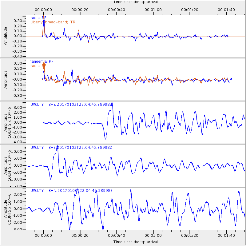
Signal To Noise
| Channel | StoN | STA | LTA |
| UW:LTY: :BHZ:20170103T22:04:45.38998Z | 20.216503 | 4.13071E-6 | 2.0432364E-7 |
| UW:LTY: :BHN:20170103T22:04:45.38998Z | 1.4627774 | 2.552136E-7 | 1.7447194E-7 |
| UW:LTY: :BHE:20170103T22:04:45.38998Z | 8.854663 | 1.4509691E-6 | 1.6386497E-7 |
| Arrivals |
| Ps | 3.4 SECOND |
| PpPs | 11 SECOND |
| PsPs/PpSs | 15 SECOND |


