You are here: Home > Network List > UW - Pacific Northwest Regional Seismic Network Stations List
> Station UMAT Pilot Rock, OR, USA > Earthquake Result Viewer
UMAT Pilot Rock, OR, USA - Earthquake Result Viewer
| Earthquake location: |
South Of Fiji Islands |
| Earthquake latitude/longitude: |
-19.3/176.1 |
| Earthquake time(UTC): |
2017/01/03 (003) 21:52:31 GMT |
| Earthquake Depth: |
17 km |
| Earthquake Magnitude: |
6.9 Mww |
| Earthquake Catalog/Contributor: |
NEIC PDE/us |
|
| Network: |
UW Pacific Northwest Regional Seismic Network |
| Station: |
UMAT Pilot Rock, OR, USA |
| Lat/Lon: |
45.29 N/118.96 W |
| Elevation: |
1318 m |
|
| Distance: |
87.2 deg |
| Az: |
39.826 deg |
| Baz: |
238.96 deg |
| Ray Param: |
0.043481916 |
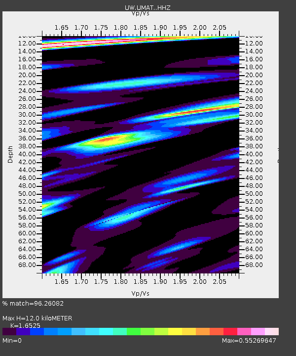
| Estimated Moho Depth: |
12.0 km |
| Estimated Crust Vp/Vs: |
1.65 |
| Assumed Crust Vp: |
6.571 km/s |
| Estimated Crust Vs: |
3.976 km/s |
| Estimated Crust Poisson's Ratio: |
0.21 |
|
| Radial Match: |
96.26082 % |
| Radial Bump: |
268 |
| Transverse Match: |
94.059944 % |
| Transverse Bump: |
350 |
| SOD ConfigId: |
11737051 |
| Insert Time: |
2019-04-26 12:45:02.058 +0000 |
| GWidth: |
2.5 |
| Max Bumps: |
400 |
| Tol: |
0.001 |
|
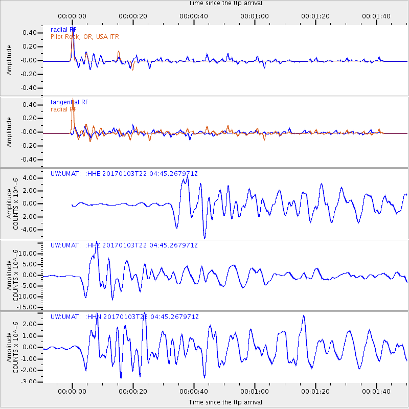
Signal To Noise
| Channel | StoN | STA | LTA |
| UW:UMAT: :HHZ:20170103T22:04:45.267971Z | 30.019438 | 4.117181E-6 | 1.3715051E-7 |
| UW:UMAT: :HHN:20170103T22:04:45.267971Z | 4.8599653 | 7.56749E-7 | 1.5571077E-7 |
| UW:UMAT: :HHE:20170103T22:04:45.267971Z | 10.066355 | 1.4513439E-6 | 1.441777E-7 |
| Arrivals |
| Ps | 1.2 SECOND |
| PpPs | 4.7 SECOND |
| PsPs/PpSs | 5.9 SECOND |


