You are here: Home > Network List > UW - Pacific Northwest Regional Seismic Network Stations List
> Station WOLL Wollman Farm, Schrag, WA, USA > Earthquake Result Viewer
WOLL Wollman Farm, Schrag, WA, USA - Earthquake Result Viewer

| Earthquake location: |
South Of Fiji Islands |
| Earthquake latitude/longitude: |
-19.3/176.1 |
| Earthquake time(UTC): |
2017/01/03 (003) 21:52:31 GMT |
| Earthquake Depth: |
17 km |
| Earthquake Magnitude: |
6.9 Mww |
| Earthquake Catalog/Contributor: |
NEIC PDE/us |
|
| Network: |
UW Pacific Northwest Regional Seismic Network |
| Station: |
WOLL Wollman Farm, Schrag, WA, USA |
| Lat/Lon: |
47.06 N/118.92 W |
| Elevation: |
385 m |
|
| Distance: |
88.1 deg |
| Az: |
38.325 deg |
| Baz: |
238.926 deg |
| Ray Param: |
0.042799275 |
| Estimated Moho Depth: |
29.0 km |
| Estimated Crust Vp/Vs: |
1.82 |
| Assumed Crust Vp: |
6.419 km/s |
| Estimated Crust Vs: |
3.537 km/s |
| Estimated Crust Poisson's Ratio: |
0.28 |
|
| Radial Match: |
95.29496 % |
| Radial Bump: |
352 |
| Transverse Match: |
86.41389 % |
| Transverse Bump: |
357 |
| SOD ConfigId: |
11737051 |
| Insert Time: |
2019-04-26 12:45:03.168 +0000 |
| GWidth: |
2.5 |
| Max Bumps: |
400 |
| Tol: |
0.001 |
|
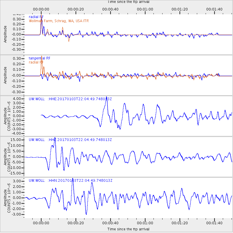
Signal To Noise
| Channel | StoN | STA | LTA |
| UW:WOLL: :HHZ:20170103T22:04:49.748013Z | 39.88871 | 4.616988E-6 | 1.1574674E-7 |
| UW:WOLL: :HHN:20170103T22:04:49.748013Z | 3.6521208 | 7.4508216E-7 | 2.0401356E-7 |
| UW:WOLL: :HHE:20170103T22:04:49.748013Z | 5.780359 | 1.0379349E-6 | 1.7956238E-7 |
| Arrivals |
| Ps | 3.8 SECOND |
| PpPs | 12 SECOND |
| PsPs/PpSs | 16 SECOND |


