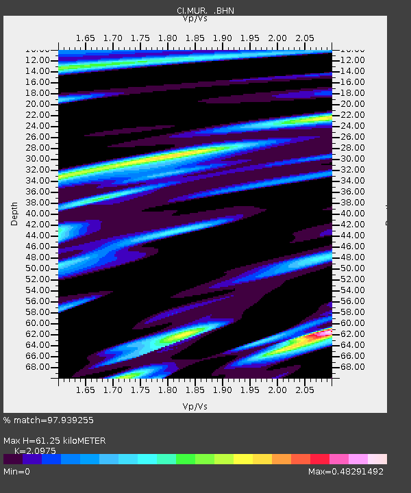
MUR Murrieta - Earthquake Result Viewer
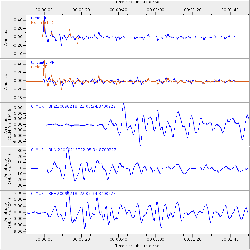
Earthquake location: Kermadec Islands Region
Earthquake latitude/longitude: -27.4/-176.3
Earthquake time(UTC): 2009/02/18 (049) 21:53:45 GMT
Earthquake Depth: 25 km
Earthquake Magnitude: 6.8 MB, 7.2 MS, 6.9 MW, 6.9 MW
Earthquake Catalog/Contributor: WHDF/NEIC
Network: CI Caltech Regional Seismic Network
Station: MUR Murrieta
Lat/Lon: 33.60 N/117.20 W
Elevation: 562 m
Distance: 82.6 deg
Az: 46.252 deg
Baz: 230.295 deg
Ray Param: 0.046725474
Estimated Moho Depth: 61.25 km
Estimated Crust Vp/Vs: 2.10
Assumed Crust Vp: 6.264 km/s
Estimated Crust Vs: 2.986 km/s
Estimated Crust Poisson's Ratio: 0.35
Radial Match: 97.939255 %
Radial Bump: 249
Transverse Match: 92.361404 %
Transverse Bump: 308
SOD ConfigId: 2658
Insert Time: 2010-03-05 21:14:23.421 +0000
GWidth: 2.5
Max Bumps: 400
Tol: 0.001

Signal To Noise

ChannelStoNSTALTA
CI:MUR: :BHN:20090218T22:05:34.870022Z12.8856793.6023002E-62.7955844E-7
CI:MUR: :BHE:20090218T22:05:34.870022Z4.7540919.144087E-71.9234146E-7
CI:MUR: :BHZ:20090218T22:05:34.870022Z4.6819581.1751839E-62.5100266E-7
Arrivals
Ps11 SECOND
PpPs30 SECOND
PsPs/PpSs41 SECOND