You are here: Home > Network List > YT07 - POLENET Stations List
> Station SILY SILY > Earthquake Result Viewer
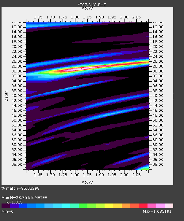
SILY SILY - Earthquake Result Viewer
| Earthquake location: |
South Of Fiji Islands |
| Earthquake latitude/longitude: |
-19.3/176.1 |
| Earthquake time(UTC): |
2017/01/03 (003) 21:52:31 GMT |
| Earthquake Depth: |
17 km |
| Earthquake Magnitude: |
6.9 Mww |
| Earthquake Catalog/Contributor: |
NEIC PDE/us |
|
| Network: |
YT POLENET |
| Station: |
SILY SILY |
| Lat/Lon: |
77.13 S/125.97 W |
| Elevation: |
2093 m |
|
| Distance: |
64.4 deg |
| Az: |
167.832 deg |
| Baz: |
297.354 deg |
| Ray Param: |
0.05896058 |
| Estimated Moho Depth: |
28.75 km |
| Estimated Crust Vp/Vs: |
1.83 |
| Assumed Crust Vp: |
6.138 km/s |
| Estimated Crust Vs: |
3.363 km/s |
| Estimated Crust Poisson's Ratio: |
0.29 |
|
| Radial Match: |
95.63298 % |
| Radial Bump: |
400 |
| Transverse Match: |
85.39458 % |
| Transverse Bump: |
400 |
| SOD ConfigId: |
11737051 |
| Insert Time: |
2019-04-26 12:45:53.279 +0000 |
| GWidth: |
2.5 |
| Max Bumps: |
400 |
| Tol: |
0.001 |
|

Signal To Noise
| Channel | StoN | STA | LTA |
| YT:SILY: :BHZ:20170103T22:02:34.899014Z | 28.091934 | 3.3940025E-6 | 1.2081769E-7 |
| YT:SILY: :BHN:20170103T22:02:34.899014Z | 6.7551265 | 8.0684737E-7 | 1.1944223E-7 |
| YT:SILY: :BHE:20170103T22:02:34.899014Z | 11.175484 | 1.428834E-6 | 1.2785434E-7 |
| Arrivals |
| Ps | 4.0 SECOND |
| PpPs | 13 SECOND |
| PsPs/PpSs | 17 SECOND |


