You are here: Home > Network List > YX16 - Raton Basin UNM Broadband Network Stations List
> Station UNM6 NE Corner of CO Stations > Earthquake Result Viewer
UNM6 NE Corner of CO Stations - Earthquake Result Viewer
| Earthquake location: |
South Of Fiji Islands |
| Earthquake latitude/longitude: |
-19.3/176.1 |
| Earthquake time(UTC): |
2017/01/03 (003) 21:52:31 GMT |
| Earthquake Depth: |
17 km |
| Earthquake Magnitude: |
6.9 Mww |
| Earthquake Catalog/Contributor: |
NEIC PDE/us |
|
| Network: |
YX Raton Basin UNM Broadband Network |
| Station: |
UNM6 NE Corner of CO Stations |
| Lat/Lon: |
37.35 N/104.72 W |
| Elevation: |
2084 m |
|
| Distance: |
93.3 deg |
| Az: |
51.643 deg |
| Baz: |
248.319 deg |
| Ray Param: |
0.041279484 |
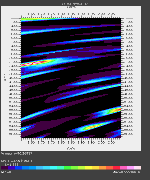
| Estimated Moho Depth: |
32.5 km |
| Estimated Crust Vp/Vs: |
1.65 |
| Assumed Crust Vp: |
6.316 km/s |
| Estimated Crust Vs: |
3.816 km/s |
| Estimated Crust Poisson's Ratio: |
0.21 |
|
| Radial Match: |
90.26937 % |
| Radial Bump: |
400 |
| Transverse Match: |
68.16448 % |
| Transverse Bump: |
400 |
| SOD ConfigId: |
11737051 |
| Insert Time: |
2019-04-26 12:46:05.697 +0000 |
| GWidth: |
2.5 |
| Max Bumps: |
400 |
| Tol: |
0.001 |
|

Signal To Noise
| Channel | StoN | STA | LTA |
| YX:UNM6: :HHZ:20170103T22:05:13.790005Z | 6.2699428 | 1.2100742E-6 | 1.9299605E-7 |
| YX:UNM6: :HHN:20170103T22:05:13.790005Z | 1.5400716 | 4.4899875E-7 | 2.9154407E-7 |
| YX:UNM6: :HHE:20170103T22:05:13.790005Z | 2.1474423 | 3.2196206E-7 | 1.4992816E-7 |
| Arrivals |
| Ps | 3.4 SECOND |
| PpPs | 13 SECOND |
| PsPs/PpSs | 17 SECOND |


