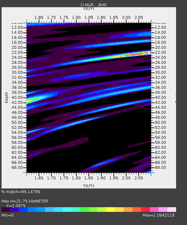
MUR Murrieta - Earthquake Result Viewer
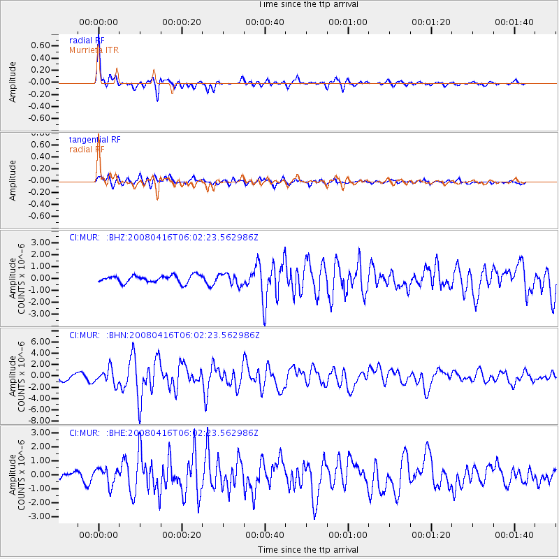
Earthquake location: Andreanof Islands, Aleutian Is.
Earthquake latitude/longitude: 51.9/-179.2
Earthquake time(UTC): 2008/04/16 (107) 05:54:19 GMT
Earthquake Depth: 13 km
Earthquake Magnitude: 6.1 MB, 6.5 MS, 6.6 MW, 6.6 MW
Earthquake Catalog/Contributor: WHDF/NEIC
Network: CI Caltech Regional Seismic Network
Station: MUR Murrieta
Lat/Lon: 33.60 N/117.20 W
Elevation: 562 m
Distance: 47.5 deg
Az: 87.383 deg
Baz: 312.102 deg
Ray Param: 0.06992822
Estimated Moho Depth: 21.75 km
Estimated Crust Vp/Vs: 2.10
Assumed Crust Vp: 6.264 km/s
Estimated Crust Vs: 2.986 km/s
Estimated Crust Poisson's Ratio: 0.35
Radial Match: 95.14795 %
Radial Bump: 400
Transverse Match: 78.62611 %
Transverse Bump: 400
SOD ConfigId: 2504
Insert Time: 2010-03-05 21:14:34.015 +0000
GWidth: 2.5
Max Bumps: 400
Tol: 0.001

Signal To Noise

ChannelStoNSTALTA
CI:MUR: :BHN:20080416T06:02:23.562986Z3.0507291.3753939E-64.5084107E-7
CI:MUR: :BHE:20080416T06:02:23.562986Z2.26583846.0723505E-72.6799577E-7
CI:MUR: :BHZ:20080416T06:02:23.562986Z1.61303114.884809E-73.0283414E-7
Arrivals
Ps4.0 SECOND
PpPs10 SECOND
PsPs/PpSs14 SECOND