You are here: Home > Network List > IW - Intermountain West Stations List
> Station MOOW Moose Ponds, Wyoming, USA > Earthquake Result Viewer
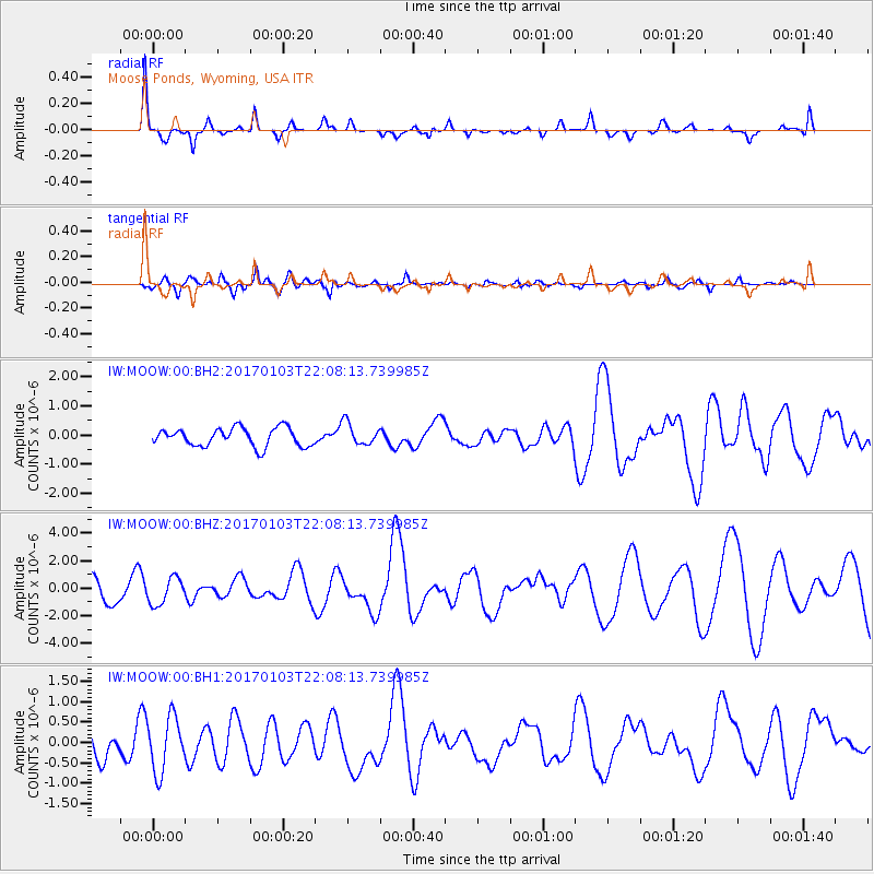
MOOW Moose Ponds, Wyoming, USA - Earthquake Result Viewer
*The percent match for this event was below the threshold and hence no stack was calculated.
| Earthquake location: |
South Of Fiji Islands |
| Earthquake latitude/longitude: |
-19.4/175.8 |
| Earthquake time(UTC): |
2017/01/03 (003) 21:55:38 GMT |
| Earthquake Depth: |
10 km |
| Earthquake Magnitude: |
5.7 mb |
| Earthquake Catalog/Contributor: |
NEIC PDE/us |
|
| Network: |
IW Intermountain West |
| Station: |
MOOW Moose Ponds, Wyoming, USA |
| Lat/Lon: |
43.75 N/110.74 W |
| Elevation: |
2128 m |
|
| Distance: |
91.9 deg |
| Az: |
44.02 deg |
| Baz: |
244.812 deg |
| Ray Param: |
$rayparam |
*The percent match for this event was below the threshold and hence was not used in the summary stack. |
|
| Radial Match: |
88.66441 % |
| Radial Bump: |
307 |
| Transverse Match: |
77.07298 % |
| Transverse Bump: |
400 |
| SOD ConfigId: |
11737051 |
| Insert Time: |
2019-04-26 12:50:38.863 +0000 |
| GWidth: |
2.5 |
| Max Bumps: |
400 |
| Tol: |
0.001 |
|
Signal To Noise
| Channel | StoN | STA | LTA |
| IW:MOOW:00:BHZ:20170103T22:08:13.739985Z | 1.2254959 | 9.623221E-7 | 7.8525113E-7 |
| IW:MOOW:00:BH1:20170103T22:08:13.739985Z | 1.4560206 | 6.7122335E-7 | 4.609985E-7 |
| IW:MOOW:00:BH2:20170103T22:08:13.739985Z | 0.6551466 | 2.0584187E-7 | 3.1419208E-7 |
| Arrivals |
| Ps | |
| PpPs | |
| PsPs/PpSs | |


