You are here: Home > Network List > GS - US Geological Survey Networks Stations List
> Station OK031 2598 S. Brethren Rd., Cushing, OK, USA > Earthquake Result Viewer
OK031 2598 S. Brethren Rd., Cushing, OK, USA - Earthquake Result Viewer
| Earthquake location: |
Near Coast Of Central Chile |
| Earthquake latitude/longitude: |
-30.9/-71.5 |
| Earthquake time(UTC): |
2015/11/07 (311) 07:31:42 GMT |
| Earthquake Depth: |
36 km |
| Earthquake Magnitude: |
6.8 MWP, 6.8 MI |
| Earthquake Catalog/Contributor: |
NEIC PDE/NEIC COMCAT |
|
| Network: |
GS US Geological Survey Networks |
| Station: |
OK031 2598 S. Brethren Rd., Cushing, OK, USA |
| Lat/Lon: |
35.95 N/96.84 W |
| Elevation: |
290 m |
|
| Distance: |
70.6 deg |
| Az: |
338.439 deg |
| Baz: |
157.089 deg |
| Ray Param: |
0.054801214 |
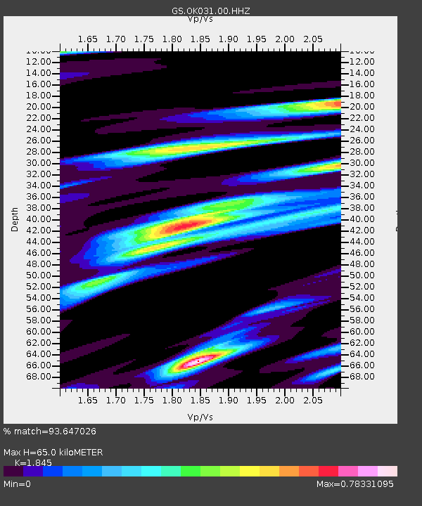
| Estimated Moho Depth: |
65.0 km |
| Estimated Crust Vp/Vs: |
1.85 |
| Assumed Crust Vp: |
6.426 km/s |
| Estimated Crust Vs: |
3.483 km/s |
| Estimated Crust Poisson's Ratio: |
0.29 |
|
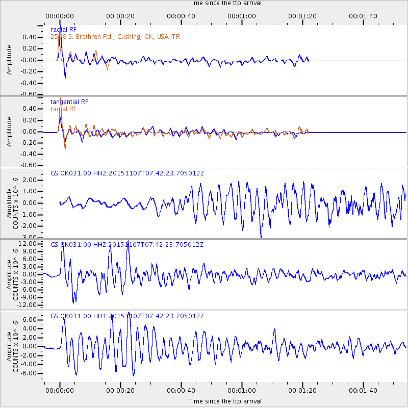
| Radial Match: |
93.647026 % |
| Radial Bump: |
280 |
| Transverse Match: |
88.76456 % |
| Transverse Bump: |
371 |
| SOD ConfigId: |
1259291 |
| Insert Time: |
2015-11-21 08:13:10.260 +0000 |
| GWidth: |
2.5 |
| Max Bumps: |
400 |
| Tol: |
0.001 |
|
Signal To Noise
| Channel | StoN | STA | LTA |
| GS:OK031:00:HHZ:20151107T07:42:23.705012Z | 15.793438 | 5.923141E-6 | 3.750381E-7 |
| GS:OK031:00:HH1:20151107T07:42:23.705012Z | 11.807286 | 2.9488729E-6 | 2.4975026E-7 |
| GS:OK031:00:HH2:20151107T07:42:23.705012Z | 2.042936 | 5.2577224E-7 | 2.5736108E-7 |
| Arrivals |
| Ps | 8.9 SECOND |
| PpPs | 28 SECOND |
| PsPs/PpSs | 37 SECOND |


