You are here: Home > Network List > TA - USArray Transportable Network (new EarthScope stations) Stations List
> Station 833A Chaparral WMA, Artesia Wells, TX, USA > Earthquake Result Viewer
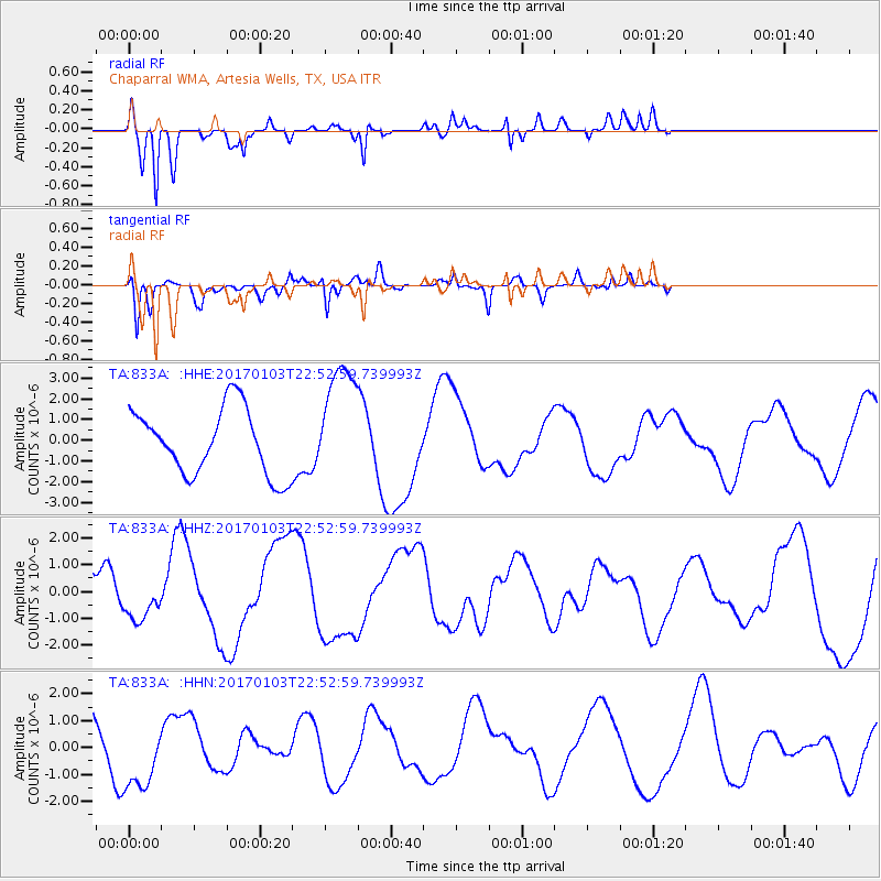
833A Chaparral WMA, Artesia Wells, TX, USA - Earthquake Result Viewer
*The percent match for this event was below the threshold and hence no stack was calculated.
| Earthquake location: |
South Of Fiji Islands |
| Earthquake latitude/longitude: |
-19.1/176.2 |
| Earthquake time(UTC): |
2017/01/03 (003) 22:40:12 GMT |
| Earthquake Depth: |
10 km |
| Earthquake Magnitude: |
5.8 mb |
| Earthquake Catalog/Contributor: |
NEIC PDE/us |
|
| Network: |
TA USArray Transportable Network (new EarthScope stations) |
| Station: |
833A Chaparral WMA, Artesia Wells, TX, USA |
| Lat/Lon: |
28.32 N/99.39 W |
| Elevation: |
171 m |
|
| Distance: |
94.2 deg |
| Az: |
61.61 deg |
| Baz: |
250.626 deg |
| Ray Param: |
$rayparam |
*The percent match for this event was below the threshold and hence was not used in the summary stack. |
|
| Radial Match: |
74.83239 % |
| Radial Bump: |
276 |
| Transverse Match: |
54.385056 % |
| Transverse Bump: |
261 |
| SOD ConfigId: |
11737051 |
| Insert Time: |
2019-04-26 12:57:10.481 +0000 |
| GWidth: |
2.5 |
| Max Bumps: |
400 |
| Tol: |
0.001 |
|
Signal To Noise
| Channel | StoN | STA | LTA |
| TA:833A: :HHZ:20170103T22:52:59.739993Z | 1.153394 | 7.570067E-7 | 6.563297E-7 |
| TA:833A: :HHN:20170103T22:52:59.739993Z | 1.617849 | 1.3927049E-6 | 8.6083736E-7 |
| TA:833A: :HHE:20170103T22:52:59.739993Z | 1.7468194 | 2.7477731E-6 | 1.5730151E-6 |
| Arrivals |
| Ps | |
| PpPs | |
| PsPs/PpSs | |


