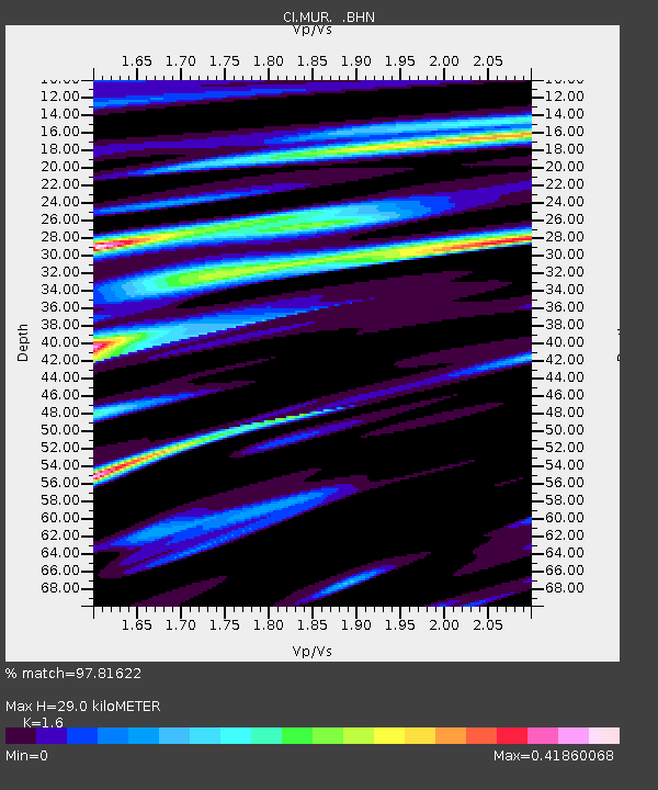
MUR Murrieta - Earthquake Result Viewer
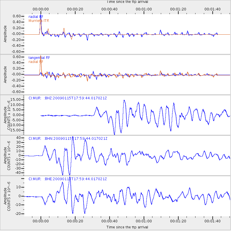
Earthquake location: East Of Kuril Islands
Earthquake latitude/longitude: 46.9/155.2
Earthquake time(UTC): 2009/01/15 (015) 17:49:39 GMT
Earthquake Depth: 36 km
Earthquake Magnitude: 6.9 MB, 7.5 MS, 7.4 MW, 7.4 MW
Earthquake Catalog/Contributor: WHDF/NEIC
Network: CI Caltech Regional Seismic Network
Station: MUR Murrieta
Lat/Lon: 33.60 N/117.20 W
Elevation: 562 m
Distance: 64.9 deg
Az: 67.05 deg
Baz: 310.786 deg
Ray Param: 0.058560304
Estimated Moho Depth: 29.0 km
Estimated Crust Vp/Vs: 1.60
Assumed Crust Vp: 6.264 km/s
Estimated Crust Vs: 3.915 km/s
Estimated Crust Poisson's Ratio: 0.18
Radial Match: 97.81622 %
Radial Bump: 284
Transverse Match: 93.25007 %
Transverse Bump: 400
SOD ConfigId: 2834
Insert Time: 2010-03-05 21:15:05.935 +0000
GWidth: 2.5
Max Bumps: 400
Tol: 0.001

Signal To Noise

ChannelStoNSTALTA
CI:MUR: :BHN:20090115T17:59:44.017021Z37.514151.0816187E-52.8832287E-7
CI:MUR: :BHE:20090115T17:59:44.017021Z20.8481374.094729E-61.9640741E-7
CI:MUR: :BHZ:20090115T17:59:44.017021Z15.4901583.8284725E-62.4715516E-7
Arrivals
Ps2.9 SECOND
PpPs12 SECOND
PsPs/PpSs14 SECOND