You are here: Home > Network List > GS - US Geological Survey Networks Stations List
> Station DEC10 Decatur Surface Seismic Site, Decatur, IL, USA > Earthquake Result Viewer
DEC10 Decatur Surface Seismic Site, Decatur, IL, USA - Earthquake Result Viewer
| Earthquake location: |
Near Coast Of Central Chile |
| Earthquake latitude/longitude: |
-30.9/-71.5 |
| Earthquake time(UTC): |
2015/11/07 (311) 07:31:42 GMT |
| Earthquake Depth: |
36 km |
| Earthquake Magnitude: |
6.8 MWP, 6.8 MI |
| Earthquake Catalog/Contributor: |
NEIC PDE/NEIC COMCAT |
|
| Network: |
GS US Geological Survey Networks |
| Station: |
DEC10 Decatur Surface Seismic Site, Decatur, IL, USA |
| Lat/Lon: |
39.89 N/88.92 W |
| Elevation: |
210 m |
|
| Distance: |
72.3 deg |
| Az: |
346.042 deg |
| Baz: |
164.367 deg |
| Ray Param: |
0.053719223 |
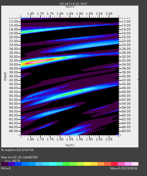
| Estimated Moho Depth: |
32.25 km |
| Estimated Crust Vp/Vs: |
1.69 |
| Assumed Crust Vp: |
6.444 km/s |
| Estimated Crust Vs: |
3.819 km/s |
| Estimated Crust Poisson's Ratio: |
0.23 |
|
| Radial Match: |
82.076744 % |
| Radial Bump: |
400 |
| Transverse Match: |
79.09207 % |
| Transverse Bump: |
400 |
| SOD ConfigId: |
1259291 |
| Insert Time: |
2015-11-21 08:14:06.158 +0000 |
| GWidth: |
2.5 |
| Max Bumps: |
400 |
| Tol: |
0.001 |
|

Signal To Noise
| Channel | StoN | STA | LTA |
| GS:DEC10:01:HHZ:20151107T07:42:33.559993Z | 16.65208 | 5.8177156E-6 | 3.493687E-7 |
| GS:DEC10:01:HHN:20151107T07:42:33.559993Z | 4.451355 | 2.288376E-6 | 5.1408523E-7 |
| GS:DEC10:01:HHE:20151107T07:42:33.559993Z | 1.5575129 | 7.349787E-7 | 4.7189252E-7 |
| Arrivals |
| Ps | 3.6 SECOND |
| PpPs | 13 SECOND |
| PsPs/PpSs | 17 SECOND |


