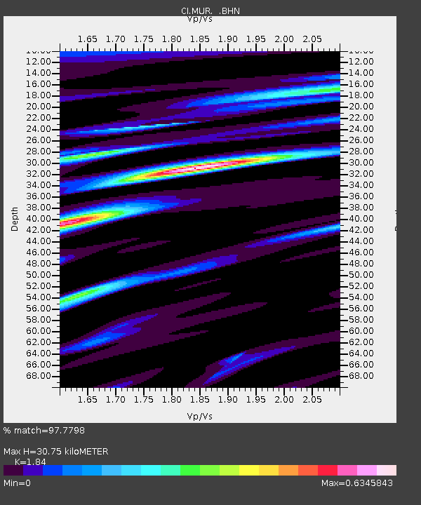
MUR Murrieta - Earthquake Result Viewer
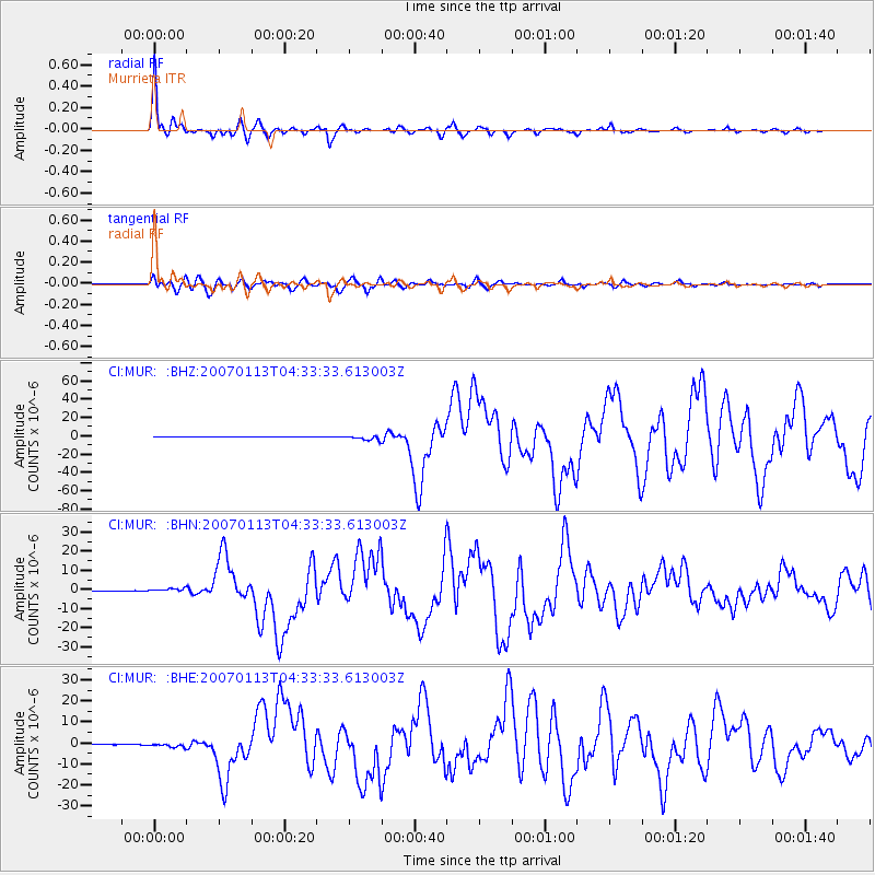
Earthquake location: East Of Kuril Islands
Earthquake latitude/longitude: 46.2/154.5
Earthquake time(UTC): 2007/01/13 (013) 04:23:21 GMT
Earthquake Depth: 10 km
Earthquake Magnitude: 7.3 MB, 8.2 MS, 8.1 MW, 7.9 MW
Earthquake Catalog/Contributor: WHDF/NEIC
Network: CI Caltech Regional Seismic Network
Station: MUR Murrieta
Lat/Lon: 33.60 N/117.20 W
Elevation: 562 m
Distance: 65.5 deg
Az: 66.413 deg
Baz: 310.354 deg
Ray Param: 0.058200058
Estimated Moho Depth: 30.75 km
Estimated Crust Vp/Vs: 1.84
Assumed Crust Vp: 6.264 km/s
Estimated Crust Vs: 3.404 km/s
Estimated Crust Poisson's Ratio: 0.29
Radial Match: 97.7798 %
Radial Bump: 319
Transverse Match: 91.10931 %
Transverse Bump: 400
SOD ConfigId: 2564
Insert Time: 2010-03-05 21:16:10.052 +0000
GWidth: 2.5
Max Bumps: 400
Tol: 0.001

Signal To Noise

ChannelStoNSTALTA
CI:MUR: :BHN:20070113T04:33:33.613003Z6.92826189.3348933E-71.3473644E-7
CI:MUR: :BHE:20070113T04:33:33.613003Z4.231259.075666E-72.1449138E-7
CI:MUR: :BHZ:20070113T04:33:33.613003Z14.9916732.6178177E-61.7461811E-7
Arrivals
Ps4.3 SECOND
PpPs13 SECOND
PsPs/PpSs18 SECOND