You are here: Home > Network List > UW - Pacific Northwest Regional Seismic Network Stations List
> Station LEBA Lebam, WA, USA > Earthquake Result Viewer
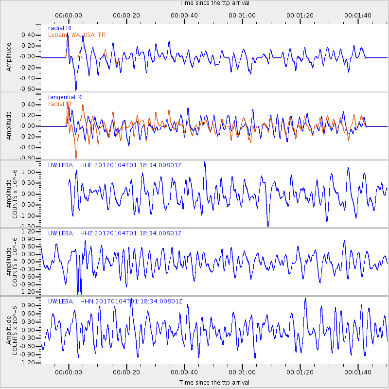
LEBA Lebam, WA, USA - Earthquake Result Viewer
*The percent match for this event was below the threshold and hence no stack was calculated.
| Earthquake location: |
Vanuatu Islands |
| Earthquake latitude/longitude: |
-17.9/167.1 |
| Earthquake time(UTC): |
2017/01/04 (004) 01:06:10 GMT |
| Earthquake Depth: |
15 km |
| Earthquake Magnitude: |
5.7 mb |
| Earthquake Catalog/Contributor: |
NEIC PDE/us |
|
| Network: |
UW Pacific Northwest Regional Seismic Network |
| Station: |
LEBA Lebam, WA, USA |
| Lat/Lon: |
46.55 N/123.56 W |
| Elevation: |
73 m |
|
| Distance: |
89.3 deg |
| Az: |
40.218 deg |
| Baz: |
242.994 deg |
| Ray Param: |
$rayparam |
*The percent match for this event was below the threshold and hence was not used in the summary stack. |
|
| Radial Match: |
71.33394 % |
| Radial Bump: |
400 |
| Transverse Match: |
57.49116 % |
| Transverse Bump: |
400 |
| SOD ConfigId: |
11737051 |
| Insert Time: |
2019-04-26 13:11:39.621 +0000 |
| GWidth: |
2.5 |
| Max Bumps: |
400 |
| Tol: |
0.001 |
|
Signal To Noise
| Channel | StoN | STA | LTA |
| UW:LEBA: :HHZ:20170104T01:18:34.00801Z | 2.2239125 | 5.7440957E-7 | 2.5828786E-7 |
| UW:LEBA: :HHN:20170104T01:18:34.00801Z | 0.8950435 | 4.385743E-7 | 4.9000334E-7 |
| UW:LEBA: :HHE:20170104T01:18:34.00801Z | 1.1403039 | 4.789043E-7 | 4.1997959E-7 |
| Arrivals |
| Ps | |
| PpPs | |
| PsPs/PpSs | |


