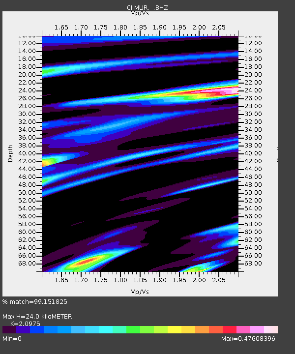
MUR Murrieta - Earthquake Result Viewer
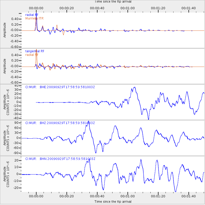
Earthquake location: Samoa Islands Region
Earthquake latitude/longitude: -15.5/-172.1
Earthquake time(UTC): 2009/09/29 (272) 17:48:10 GMT
Earthquake Depth: 18 km
Earthquake Magnitude: 7.1 MB, 8.1 MS, 8.1 MW, 8.0 MW
Earthquake Catalog/Contributor: WHDF/NEIC
Network: CI Caltech Regional Seismic Network
Station: MUR Murrieta
Lat/Lon: 33.60 N/117.20 W
Elevation: 562 m
Distance: 71.5 deg
Az: 46.043 deg
Baz: 236.26 deg
Ray Param: 0.054239556
Estimated Moho Depth: 24.0 km
Estimated Crust Vp/Vs: 2.10
Assumed Crust Vp: 6.264 km/s
Estimated Crust Vs: 2.986 km/s
Estimated Crust Poisson's Ratio: 0.35
Radial Match: 99.151825 %
Radial Bump: 250
Transverse Match: 94.80637 %
Transverse Bump: 400
SOD ConfigId: 2622
Insert Time: 2010-03-05 21:16:36.026 +0000
GWidth: 2.5
Max Bumps: 400
Tol: 0.001

Signal To Noise

ChannelStoNSTALTA
CI:MUR: :BHZ:20090929T17:58:59.581003Z12.8113163.3059173E-62.5804667E-7
CI:MUR: :BHN:20090929T17:58:59.581003Z2.90318755.5918935E-71.9261222E-7
CI:MUR: :BHE:20090929T17:58:59.581003Z4.54757261.1009826E-62.4210337E-7
Arrivals
Ps4.3 SECOND
PpPs12 SECOND
PsPs/PpSs16 SECOND