You are here: Home > Network List > CI - Caltech Regional Seismic Network Stations List
> Station MUR Murrieta > Earthquake Result Viewer
MUR Murrieta - Earthquake Result Viewer
| Earthquake location: |
Santa Cruz Islands |
| Earthquake latitude/longitude: |
-11.5/166.0 |
| Earthquake time(UTC): |
2009/10/07 (280) 22:29:18 GMT |
| Earthquake Depth: |
35 km |
| Earthquake Magnitude: |
5.5 MB |
| Earthquake Catalog/Contributor: |
WHDF/NEIC |
|
| Network: |
CI Caltech Regional Seismic Network |
| Station: |
MUR Murrieta |
| Lat/Lon: |
33.60 N/117.20 W |
| Elevation: |
562 m |
|
| Distance: |
85.5 deg |
| Az: |
54.585 deg |
| Baz: |
253.152 deg |
| Ray Param: |
0.044653382 |
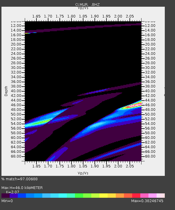
| Estimated Moho Depth: |
46.0 km |
| Estimated Crust Vp/Vs: |
2.07 |
| Assumed Crust Vp: |
6.264 km/s |
| Estimated Crust Vs: |
3.026 km/s |
| Estimated Crust Poisson's Ratio: |
0.35 |
|
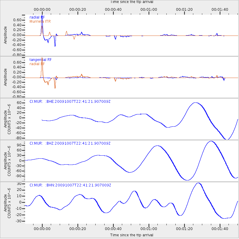
| Radial Match: |
97.00688 % |
| Radial Bump: |
277 |
| Transverse Match: |
47.945503 % |
| Transverse Bump: |
400 |
| SOD ConfigId: |
2622 |
| Insert Time: |
2010-03-05 21:16:40.114 +0000 |
| GWidth: |
2.5 |
| Max Bumps: |
400 |
| Tol: |
0.001 |
|
Signal To Noise
| Channel | StoN | STA | LTA |
| CI:MUR: :BHZ:20091007T22:41:21.907009Z | 2.3452024 | 1.3706949E-5 | 5.8446763E-6 |
| CI:MUR: :BHN:20091007T22:41:21.907009Z | 1.370878 | 6.2494873E-6 | 4.558748E-6 |
| CI:MUR: :BHE:20091007T22:41:21.907009Z | 1.8189199 | 1.4415499E-5 | 7.925308E-6 |
| Arrivals |
| Ps | 8.0 SECOND |
| PpPs | 22 SECOND |
| PsPs/PpSs | 30 SECOND |


