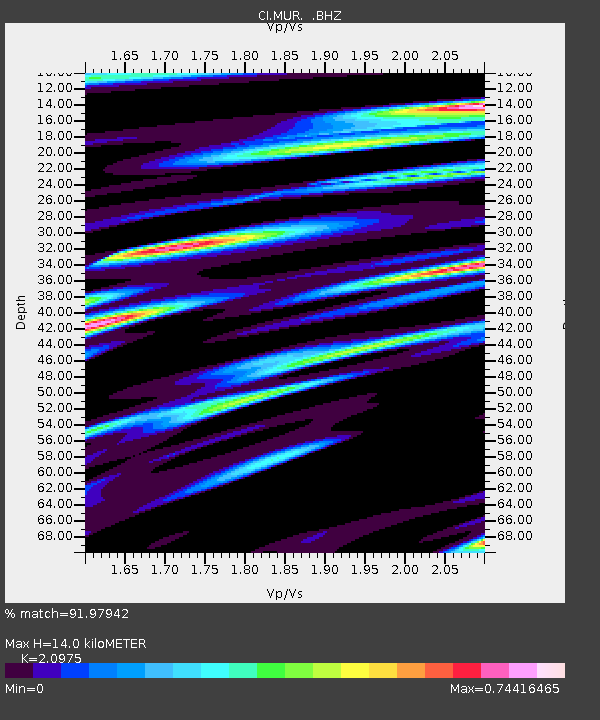
MUR Murrieta - Earthquake Result Viewer

Earthquake location: Fox Islands, Aleutian Islands
Earthquake latitude/longitude: 52.8/-167.0
Earthquake time(UTC): 2009/10/13 (286) 05:37:23 GMT
Earthquake Depth: 24 km
Earthquake Magnitude: 6.0 MB, 6.1 MS, 6.5 MW, 6.5 MW
Earthquake Catalog/Contributor: WHDF/NEIC
Network: CI Caltech Regional Seismic Network
Station: MUR Murrieta
Lat/Lon: 33.60 N/117.20 W
Elevation: 562 m
Distance: 40.1 deg
Az: 98.298 deg
Baz: 313.894 deg
Ray Param: 0.07454479
Estimated Moho Depth: 14.0 km
Estimated Crust Vp/Vs: 2.10
Assumed Crust Vp: 6.264 km/s
Estimated Crust Vs: 2.986 km/s
Estimated Crust Poisson's Ratio: 0.35
Radial Match: 91.97942 %
Radial Bump: 354
Transverse Match: 66.433426 %
Transverse Bump: 400
SOD ConfigId: 2622
Insert Time: 2010-03-05 21:16:47.008 +0000
GWidth: 2.5
Max Bumps: 400
Tol: 0.001

Signal To Noise

ChannelStoNSTALTA
CI:MUR: :BHZ:20091013T05:44:26.63101Z3.96824985.6267254E-71.4179363E-7
CI:MUR: :BHN:20091013T05:44:26.63101Z2.07266524.8132796E-72.322266E-7
CI:MUR: :BHE:20091013T05:44:26.63101Z0.92087711.8573617E-72.0169485E-7
Arrivals
Ps2.6 SECOND
PpPs6.5 SECOND
PsPs/PpSs9.1 SECOND