You are here: Home > Network List > TA - USArray Transportable Network (new EarthScope stations) Stations List
> Station F21K Alatna River, AK, USA > Earthquake Result Viewer
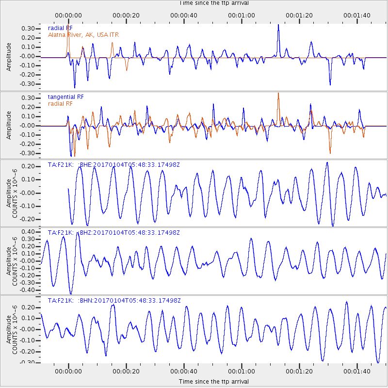
F21K Alatna River, AK, USA - Earthquake Result Viewer
*The percent match for this event was below the threshold and hence no stack was calculated.
| Earthquake location: |
South Of Fiji Islands |
| Earthquake latitude/longitude: |
-19.2/176.0 |
| Earthquake time(UTC): |
2017/01/04 (004) 05:36:09 GMT |
| Earthquake Depth: |
10 km |
| Earthquake Magnitude: |
5.5 mb |
| Earthquake Catalog/Contributor: |
NEIC PDE/us |
|
| Network: |
TA USArray Transportable Network (new EarthScope stations) |
| Station: |
F21K Alatna River, AK, USA |
| Lat/Lon: |
67.22 N/153.48 W |
| Elevation: |
597 m |
|
| Distance: |
89.0 deg |
| Az: |
11.396 deg |
| Baz: |
208.665 deg |
| Ray Param: |
$rayparam |
*The percent match for this event was below the threshold and hence was not used in the summary stack. |
|
| Radial Match: |
64.72069 % |
| Radial Bump: |
399 |
| Transverse Match: |
59.435402 % |
| Transverse Bump: |
400 |
| SOD ConfigId: |
11737051 |
| Insert Time: |
2019-04-26 13:16:56.081 +0000 |
| GWidth: |
2.5 |
| Max Bumps: |
400 |
| Tol: |
0.001 |
|
Signal To Noise
| Channel | StoN | STA | LTA |
| TA:F21K: :BHZ:20170104T05:48:33.17498Z | 2.1195502 | 2.8192792E-7 | 1.3301309E-7 |
| TA:F21K: :BHN:20170104T05:48:33.17498Z | 0.83764035 | 6.9247825E-8 | 8.267011E-8 |
| TA:F21K: :BHE:20170104T05:48:33.17498Z | 0.99251914 | 1.4114856E-7 | 1.4221243E-7 |
| Arrivals |
| Ps | |
| PpPs | |
| PsPs/PpSs | |


