MUR Murrieta - Earthquake Result Viewer
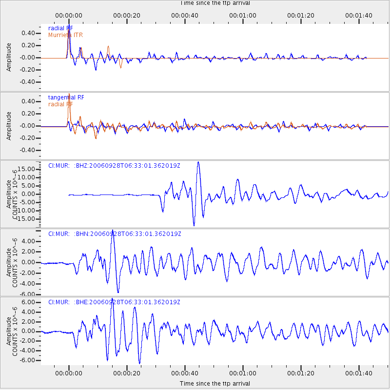
Earthquake location: Samoa Islands Region
Earthquake latitude/longitude: -16.6/-172.0
Earthquake time(UTC): 2006/09/28 (271) 06:22:09 GMT
Earthquake Depth: 28 km
Earthquake Magnitude: 6.5 MB, 6.6 MS, 6.9 MW, 6.7 MW
Earthquake Catalog/Contributor: WHDF/NEIC
Network: CI Caltech Regional Seismic Network
Station: MUR Murrieta
Lat/Lon: 33.60 N/117.20 W
Elevation: 562 m
Distance: 72.3 deg
Az: 45.755 deg
Baz: 235.388 deg
Ray Param: 0.053736098
Estimated Moho Depth: 66.25 km
Estimated Crust Vp/Vs: 1.73
Assumed Crust Vp: 6.264 km/s
Estimated Crust Vs: 3.631 km/s
Estimated Crust Poisson's Ratio: 0.25
Radial Match: 96.24964 %
Radial Bump: 352
Transverse Match: 89.972885 %
Transverse Bump: 400
SOD ConfigId: 2665
Insert Time: 2010-03-05 21:17:38.783 +0000
GWidth: 2.5
Max Bumps: 400
Tol: 0.001

Signal To Noise

ChannelStoNSTALTA
CI:MUR: :BHN:20060928T06:33:01.362019Z10.7371019.12131E-78.495134E-8
CI:MUR: :BHE:20060928T06:33:01.362019Z13.2627511.3346892E-61.00634416E-7
CI:MUR: :BHZ:20060928T06:33:01.362019Z22.2591423.8596704E-61.7339708E-7
Arrivals
Ps7.9 SECOND
PpPs28 SECOND
PsPs/PpSs36 SECOND