You are here: Home > Network List > AV - Alaska Volcano Observatory Stations List
> Station SPCR Ckakachatna River, Mount Spurr, Alaska > Earthquake Result Viewer
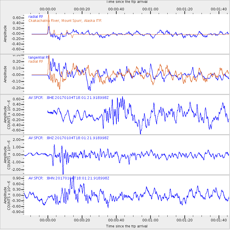
SPCR Ckakachatna River, Mount Spurr, Alaska - Earthquake Result Viewer
*The percent match for this event was below the threshold and hence no stack was calculated.
| Earthquake location: |
Near East Coast Of Honshu, Japan |
| Earthquake latitude/longitude: |
37.1/141.3 |
| Earthquake time(UTC): |
2017/01/04 (004) 17:53:20 GMT |
| Earthquake Depth: |
10 km |
| Earthquake Magnitude: |
5.6 mb |
| Earthquake Catalog/Contributor: |
NEIC PDE/us |
|
| Network: |
AV Alaska Volcano Observatory |
| Station: |
SPCR Ckakachatna River, Mount Spurr, Alaska |
| Lat/Lon: |
61.20 N/152.21 W |
| Elevation: |
984 m |
|
| Distance: |
47.1 deg |
| Az: |
37.289 deg |
| Baz: |
270.914 deg |
| Ray Param: |
$rayparam |
*The percent match for this event was below the threshold and hence was not used in the summary stack. |
|
| Radial Match: |
64.85499 % |
| Radial Bump: |
400 |
| Transverse Match: |
56.654346 % |
| Transverse Bump: |
400 |
| SOD ConfigId: |
11737051 |
| Insert Time: |
2019-04-26 13:20:42.028 +0000 |
| GWidth: |
2.5 |
| Max Bumps: |
400 |
| Tol: |
0.001 |
|
Signal To Noise
| Channel | StoN | STA | LTA |
| AV:SPCR: :BHZ:20170104T18:01:21.918998Z | 2.9767392 | 5.13073E-7 | 1.7236077E-7 |
| AV:SPCR: :BHN:20170104T18:01:21.918998Z | 1.0892256 | 1.9939613E-7 | 1.8306228E-7 |
| AV:SPCR: :BHE:20170104T18:01:21.918998Z | 1.3322808 | 1.8894097E-7 | 1.4181768E-7 |
| Arrivals |
| Ps | |
| PpPs | |
| PsPs/PpSs | |


