You are here: Home > Network List > IC - New China Digital Seismograph Network Stations List
> Station WMQ Urumqi, Xinjiang Province, China > Earthquake Result Viewer
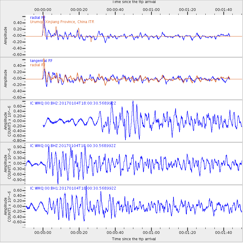
WMQ Urumqi, Xinjiang Province, China - Earthquake Result Viewer
*The percent match for this event was below the threshold and hence no stack was calculated.
| Earthquake location: |
Near East Coast Of Honshu, Japan |
| Earthquake latitude/longitude: |
37.1/141.3 |
| Earthquake time(UTC): |
2017/01/04 (004) 17:53:20 GMT |
| Earthquake Depth: |
10 km |
| Earthquake Magnitude: |
5.6 mb |
| Earthquake Catalog/Contributor: |
NEIC PDE/us |
|
| Network: |
IC New China Digital Seismograph Network |
| Station: |
WMQ Urumqi, Xinjiang Province, China |
| Lat/Lon: |
43.81 N/87.70 E |
| Elevation: |
850 m |
|
| Distance: |
40.7 deg |
| Az: |
296.712 deg |
| Baz: |
80.453 deg |
| Ray Param: |
$rayparam |
*The percent match for this event was below the threshold and hence was not used in the summary stack. |
|
| Radial Match: |
75.26279 % |
| Radial Bump: |
400 |
| Transverse Match: |
76.041275 % |
| Transverse Bump: |
400 |
| SOD ConfigId: |
11737051 |
| Insert Time: |
2019-04-26 13:22:56.451 +0000 |
| GWidth: |
2.5 |
| Max Bumps: |
400 |
| Tol: |
0.001 |
|
Signal To Noise
| Channel | StoN | STA | LTA |
| IC:WMQ:00:BHZ:20170104T18:00:30.568992Z | 3.2046497 | 3.4881432E-7 | 1.08846315E-7 |
| IC:WMQ:00:BH1:20170104T18:00:30.568992Z | 2.2549677 | 1.6460503E-7 | 7.299663E-8 |
| IC:WMQ:00:BH2:20170104T18:00:30.568992Z | 2.8055422 | 2.2662002E-7 | 8.0775834E-8 |
| Arrivals |
| Ps | |
| PpPs | |
| PsPs/PpSs | |


