You are here: Home > Network List > CI - Caltech Regional Seismic Network Stations List
> Station MUR Murrieta > Earthquake Result Viewer
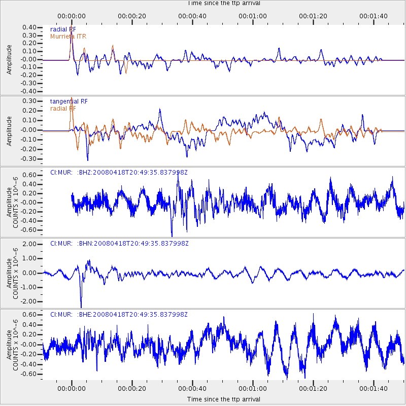
MUR Murrieta - Earthquake Result Viewer
*The percent match for this event was below the threshold and hence no stack was calculated.
| Earthquake location: |
Fiji Islands Region |
| Earthquake latitude/longitude: |
-17.3/-179.0 |
| Earthquake time(UTC): |
2008/04/18 (109) 20:39:07 GMT |
| Earthquake Depth: |
554 km |
| Earthquake Magnitude: |
5.9 MB, 6.3 MW, 6.3 MW |
| Earthquake Catalog/Contributor: |
WHDF/NEIC |
|
| Network: |
CI Caltech Regional Seismic Network |
| Station: |
MUR Murrieta |
| Lat/Lon: |
33.60 N/117.20 W |
| Elevation: |
562 m |
|
| Distance: |
77.7 deg |
| Az: |
48.856 deg |
| Baz: |
239.515 deg |
| Ray Param: |
$rayparam |
*The percent match for this event was below the threshold and hence was not used in the summary stack. |
|
| Radial Match: |
56.28972 % |
| Radial Bump: |
400 |
| Transverse Match: |
51.940407 % |
| Transverse Bump: |
400 |
| SOD ConfigId: |
2504 |
| Insert Time: |
2010-03-05 21:18:26.307 +0000 |
| GWidth: |
2.5 |
| Max Bumps: |
400 |
| Tol: |
0.001 |
|
Signal To Noise
| Channel | StoN | STA | LTA |
| CI:MUR: :BHN:20080418T20:49:35.837998Z | 5.7061586 | 6.676113E-7 | 1.1699837E-7 |
| CI:MUR: :BHE:20080418T20:49:35.837998Z | 1.1207646 | 1.3864599E-7 | 1.2370661E-7 |
| CI:MUR: :BHZ:20080418T20:49:35.837998Z | 1.6333867 | 2.3212458E-7 | 1.4211244E-7 |
| Arrivals |
| Ps | |
| PpPs | |
| PsPs/PpSs | |


