You are here: Home > Network List > TA - USArray Transportable Network (new EarthScope stations) Stations List
> Station D25K Kavik River, AK, USA > Earthquake Result Viewer
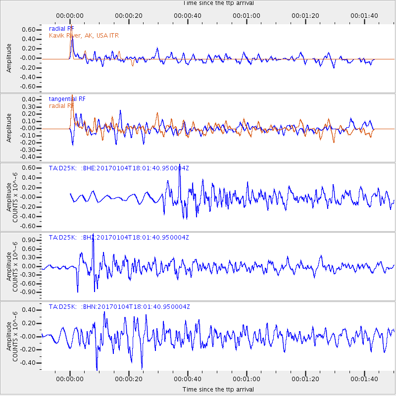
D25K Kavik River, AK, USA - Earthquake Result Viewer
*The percent match for this event was below the threshold and hence no stack was calculated.
| Earthquake location: |
Near East Coast Of Honshu, Japan |
| Earthquake latitude/longitude: |
37.1/141.3 |
| Earthquake time(UTC): |
2017/01/04 (004) 17:53:20 GMT |
| Earthquake Depth: |
10 km |
| Earthquake Magnitude: |
5.6 mb |
| Earthquake Catalog/Contributor: |
NEIC PDE/us |
|
| Network: |
TA USArray Transportable Network (new EarthScope stations) |
| Station: |
D25K Kavik River, AK, USA |
| Lat/Lon: |
69.32 N/146.38 W |
| Elevation: |
770 m |
|
| Distance: |
49.6 deg |
| Az: |
26.384 deg |
| Baz: |
268.959 deg |
| Ray Param: |
$rayparam |
*The percent match for this event was below the threshold and hence was not used in the summary stack. |
|
| Radial Match: |
67.67164 % |
| Radial Bump: |
400 |
| Transverse Match: |
62.405567 % |
| Transverse Bump: |
400 |
| SOD ConfigId: |
11737051 |
| Insert Time: |
2019-04-26 13:26:06.891 +0000 |
| GWidth: |
2.5 |
| Max Bumps: |
400 |
| Tol: |
0.001 |
|
Signal To Noise
| Channel | StoN | STA | LTA |
| TA:D25K: :BHZ:20170104T18:01:40.950004Z | 3.1293952 | 2.8459692E-7 | 9.094311E-8 |
| TA:D25K: :BHN:20170104T18:01:40.950004Z | 1.3200977 | 1.0895752E-7 | 8.253747E-8 |
| TA:D25K: :BHE:20170104T18:01:40.950004Z | 2.709708 | 1.5251905E-7 | 5.6286154E-8 |
| Arrivals |
| Ps | |
| PpPs | |
| PsPs/PpSs | |


