You are here: Home > Network List > TA - USArray Transportable Network (new EarthScope stations) Stations List
> Station MDND Maddock, ND, USA > Earthquake Result Viewer
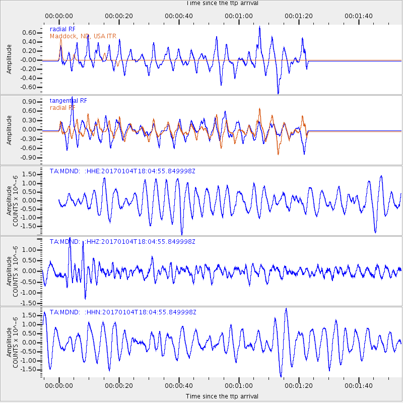
MDND Maddock, ND, USA - Earthquake Result Viewer
*The percent match for this event was below the threshold and hence no stack was calculated.
| Earthquake location: |
Near East Coast Of Honshu, Japan |
| Earthquake latitude/longitude: |
37.1/141.3 |
| Earthquake time(UTC): |
2017/01/04 (004) 17:53:20 GMT |
| Earthquake Depth: |
10 km |
| Earthquake Magnitude: |
5.6 mb |
| Earthquake Catalog/Contributor: |
NEIC PDE/us |
|
| Network: |
TA USArray Transportable Network (new EarthScope stations) |
| Station: |
MDND Maddock, ND, USA |
| Lat/Lon: |
47.85 N/99.60 W |
| Elevation: |
479 m |
|
| Distance: |
79.5 deg |
| Az: |
36.791 deg |
| Baz: |
314.718 deg |
| Ray Param: |
$rayparam |
*The percent match for this event was below the threshold and hence was not used in the summary stack. |
|
| Radial Match: |
54.863617 % |
| Radial Bump: |
340 |
| Transverse Match: |
57.391735 % |
| Transverse Bump: |
273 |
| SOD ConfigId: |
11737051 |
| Insert Time: |
2019-04-26 13:26:37.787 +0000 |
| GWidth: |
2.5 |
| Max Bumps: |
400 |
| Tol: |
0.001 |
|
Signal To Noise
| Channel | StoN | STA | LTA |
| TA:MDND: :HHZ:20170104T18:04:55.849998Z | 2.628135 | 5.450413E-7 | 2.073871E-7 |
| TA:MDND: :HHN:20170104T18:04:55.849998Z | 0.70637715 | 3.5050556E-7 | 4.962017E-7 |
| TA:MDND: :HHE:20170104T18:04:55.849998Z | 1.9350921 | 8.9747755E-7 | 4.6379063E-7 |
| Arrivals |
| Ps | |
| PpPs | |
| PsPs/PpSs | |


