You are here: Home > Network List > US - United States National Seismic Network Stations List
> Station DUG Dugway, Tooele County, Utah, USA > Earthquake Result Viewer
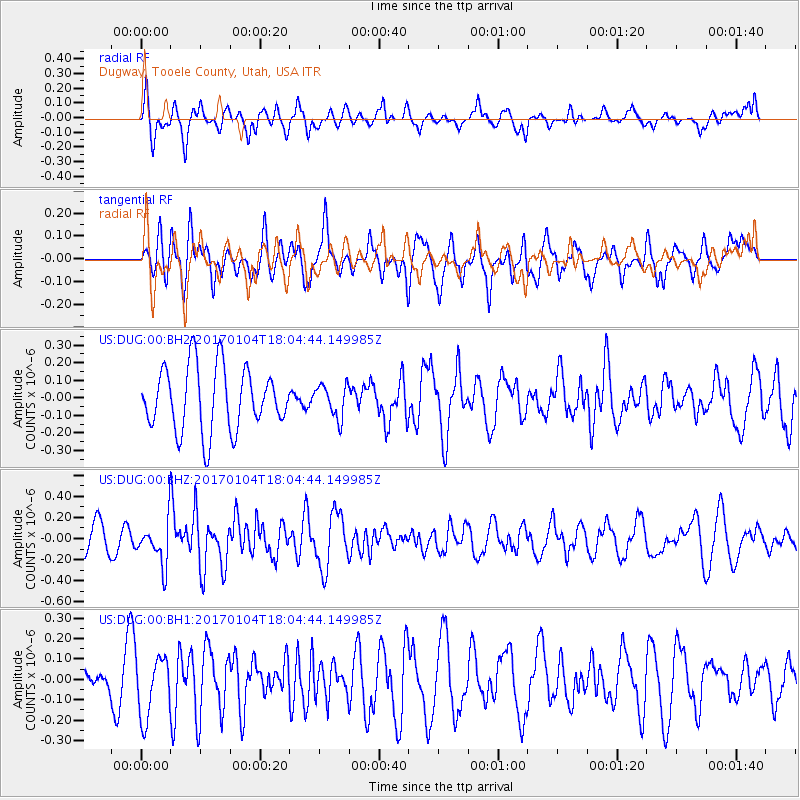
DUG Dugway, Tooele County, Utah, USA - Earthquake Result Viewer
*The percent match for this event was below the threshold and hence no stack was calculated.
| Earthquake location: |
Near East Coast Of Honshu, Japan |
| Earthquake latitude/longitude: |
37.1/141.3 |
| Earthquake time(UTC): |
2017/01/04 (004) 17:53:20 GMT |
| Earthquake Depth: |
10 km |
| Earthquake Magnitude: |
5.6 mb |
| Earthquake Catalog/Contributor: |
NEIC PDE/us |
|
| Network: |
US United States National Seismic Network |
| Station: |
DUG Dugway, Tooele County, Utah, USA |
| Lat/Lon: |
40.19 N/112.81 W |
| Elevation: |
1477 m |
|
| Distance: |
77.3 deg |
| Az: |
49.048 deg |
| Baz: |
308.002 deg |
| Ray Param: |
$rayparam |
*The percent match for this event was below the threshold and hence was not used in the summary stack. |
|
| Radial Match: |
53.3779 % |
| Radial Bump: |
400 |
| Transverse Match: |
56.519875 % |
| Transverse Bump: |
400 |
| SOD ConfigId: |
11737051 |
| Insert Time: |
2019-04-26 13:27:46.390 +0000 |
| GWidth: |
2.5 |
| Max Bumps: |
400 |
| Tol: |
0.001 |
|
Signal To Noise
| Channel | StoN | STA | LTA |
| US:DUG:00:BHZ:20170104T18:04:44.149985Z | 1.6448206 | 2.1754786E-7 | 1.3226237E-7 |
| US:DUG:00:BH1:20170104T18:04:44.149985Z | 1.9398309 | 1.5012243E-7 | 7.7389444E-8 |
| US:DUG:00:BH2:20170104T18:04:44.149985Z | 0.46651226 | 8.557929E-8 | 1.834449E-7 |
| Arrivals |
| Ps | |
| PpPs | |
| PsPs/PpSs | |


