You are here: Home > Network List > US - United States National Seismic Network Stations List
> Station ELK Elko, Nevada, USA > Earthquake Result Viewer
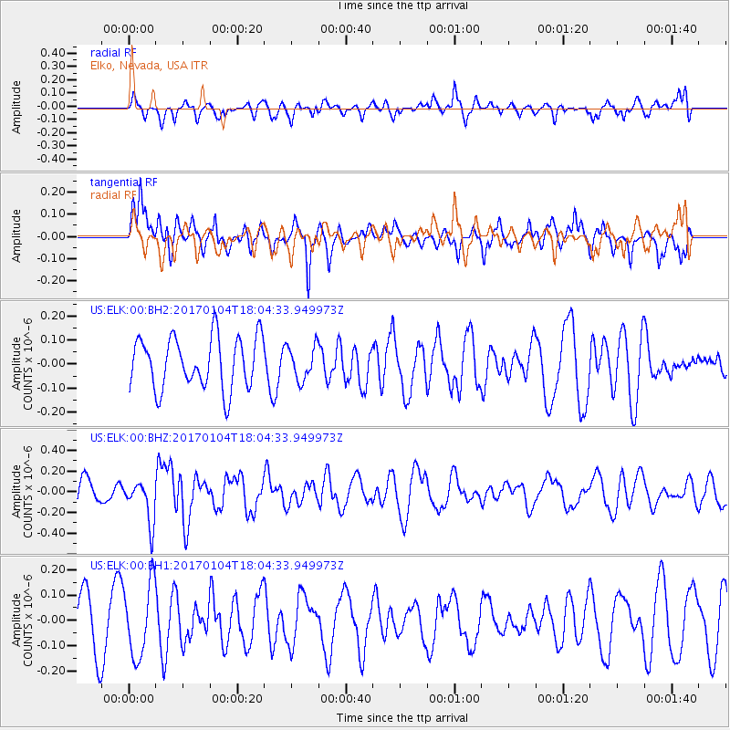
ELK Elko, Nevada, USA - Earthquake Result Viewer
*The percent match for this event was below the threshold and hence no stack was calculated.
| Earthquake location: |
Near East Coast Of Honshu, Japan |
| Earthquake latitude/longitude: |
37.1/141.3 |
| Earthquake time(UTC): |
2017/01/04 (004) 17:53:20 GMT |
| Earthquake Depth: |
10 km |
| Earthquake Magnitude: |
5.6 mb |
| Earthquake Catalog/Contributor: |
NEIC PDE/us |
|
| Network: |
US United States National Seismic Network |
| Station: |
ELK Elko, Nevada, USA |
| Lat/Lon: |
40.74 N/115.24 W |
| Elevation: |
2210 m |
|
| Distance: |
75.5 deg |
| Az: |
49.752 deg |
| Baz: |
306.599 deg |
| Ray Param: |
$rayparam |
*The percent match for this event was below the threshold and hence was not used in the summary stack. |
|
| Radial Match: |
43.865215 % |
| Radial Bump: |
400 |
| Transverse Match: |
60.260433 % |
| Transverse Bump: |
400 |
| SOD ConfigId: |
11737051 |
| Insert Time: |
2019-04-26 13:27:46.897 +0000 |
| GWidth: |
2.5 |
| Max Bumps: |
400 |
| Tol: |
0.001 |
|
Signal To Noise
| Channel | StoN | STA | LTA |
| US:ELK:00:BHZ:20170104T18:04:33.949973Z | 1.7168524 | 2.0411828E-7 | 1.1889099E-7 |
| US:ELK:00:BH1:20170104T18:04:33.949973Z | 1.366272 | 1.4405727E-7 | 1.0543821E-7 |
| US:ELK:00:BH2:20170104T18:04:33.949973Z | 0.6008457 | 6.399315E-8 | 1.06505134E-7 |
| Arrivals |
| Ps | |
| PpPs | |
| PsPs/PpSs | |


