You are here: Home > Network List > CI - Caltech Regional Seismic Network Stations List
> Station MUR Murrieta > Earthquake Result Viewer
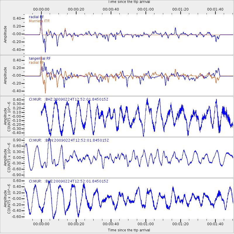
MUR Murrieta - Earthquake Result Viewer
*The percent match for this event was below the threshold and hence no stack was calculated.
| Earthquake location: |
Southeast Of Loyalty Islands |
| Earthquake latitude/longitude: |
-23.2/170.6 |
| Earthquake time(UTC): |
2009/02/24 (055) 12:39:41 GMT |
| Earthquake Depth: |
32 km |
| Earthquake Magnitude: |
5.6 MB, 5.7 MW, 5.6 MW |
| Earthquake Catalog/Contributor: |
WHDF/NEIC |
|
| Network: |
CI Caltech Regional Seismic Network |
| Station: |
MUR Murrieta |
| Lat/Lon: |
33.60 N/117.20 W |
| Elevation: |
562 m |
|
| Distance: |
88.9 deg |
| Az: |
52.657 deg |
| Baz: |
241.23 deg |
| Ray Param: |
$rayparam |
*The percent match for this event was below the threshold and hence was not used in the summary stack. |
|
| Radial Match: |
79.62389 % |
| Radial Bump: |
379 |
| Transverse Match: |
75.26152 % |
| Transverse Bump: |
400 |
| SOD ConfigId: |
2658 |
| Insert Time: |
2010-03-05 21:19:12.363 +0000 |
| GWidth: |
2.5 |
| Max Bumps: |
400 |
| Tol: |
0.001 |
|
Signal To Noise
| Channel | StoN | STA | LTA |
| CI:MUR: :BHN:20090224T12:52:01.845015Z | 1.4570404 | 4.951763E-7 | 3.3985077E-7 |
| CI:MUR: :BHE:20090224T12:52:01.845015Z | 1.5264692 | 3.5370067E-7 | 2.3171162E-7 |
| CI:MUR: :BHZ:20090224T12:52:01.845015Z | 0.8377508 | 2.1296495E-7 | 2.5421036E-7 |
| Arrivals |
| Ps | |
| PpPs | |
| PsPs/PpSs | |


