You are here: Home > Network List > CI - Caltech Regional Seismic Network Stations List
> Station DGR Domenigoni Reservoir, California, USA > Earthquake Result Viewer
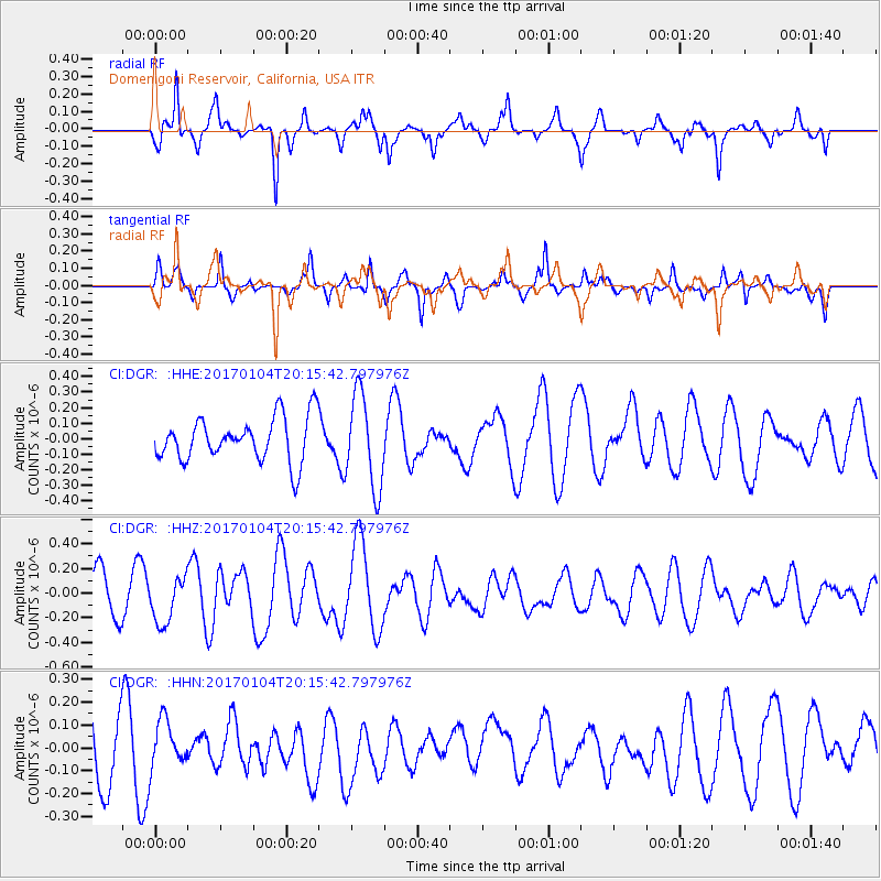
DGR Domenigoni Reservoir, California, USA - Earthquake Result Viewer
*The percent match for this event was below the threshold and hence no stack was calculated.
| Earthquake location: |
Fiji Islands Region |
| Earthquake latitude/longitude: |
-18.8/176.3 |
| Earthquake time(UTC): |
2017/01/04 (004) 20:03:52 GMT |
| Earthquake Depth: |
7.0 km |
| Earthquake Magnitude: |
5.7 Mww |
| Earthquake Catalog/Contributor: |
NEIC PDE/us |
|
| Network: |
CI Caltech Regional Seismic Network |
| Station: |
DGR Domenigoni Reservoir, California, USA |
| Lat/Lon: |
33.65 N/117.01 W |
| Elevation: |
609 m |
|
| Distance: |
82.2 deg |
| Az: |
50.665 deg |
| Baz: |
241.45 deg |
| Ray Param: |
$rayparam |
*The percent match for this event was below the threshold and hence was not used in the summary stack. |
|
| Radial Match: |
71.006226 % |
| Radial Bump: |
273 |
| Transverse Match: |
63.7324 % |
| Transverse Bump: |
347 |
| SOD ConfigId: |
11737051 |
| Insert Time: |
2019-04-26 13:31:35.275 +0000 |
| GWidth: |
2.5 |
| Max Bumps: |
400 |
| Tol: |
0.001 |
|
Signal To Noise
| Channel | StoN | STA | LTA |
| CI:DGR: :HHZ:20170104T20:15:42.797976Z | 0.8561558 | 1.8602725E-7 | 2.17282E-7 |
| CI:DGR: :HHN:20170104T20:15:42.797976Z | 0.7820064 | 1.0010159E-7 | 1.280061E-7 |
| CI:DGR: :HHE:20170104T20:15:42.797976Z | 2.1301076 | 3.001404E-7 | 1.4090388E-7 |
| Arrivals |
| Ps | |
| PpPs | |
| PsPs/PpSs | |


