You are here: Home > Network List > NM - Cooperative New Madrid Seismic Network Stations List
> Station HENM Henderson Mound,MO > Earthquake Result Viewer
HENM Henderson Mound,MO - Earthquake Result Viewer
| Earthquake location: |
Near Coast Of Central Chile |
| Earthquake latitude/longitude: |
-30.9/-71.5 |
| Earthquake time(UTC): |
2015/11/07 (311) 07:31:42 GMT |
| Earthquake Depth: |
36 km |
| Earthquake Magnitude: |
6.8 MWP, 6.8 MI |
| Earthquake Catalog/Contributor: |
NEIC PDE/NEIC COMCAT |
|
| Network: |
NM Cooperative New Madrid Seismic Network |
| Station: |
HENM Henderson Mound,MO |
| Lat/Lon: |
36.72 N/89.47 W |
| Elevation: |
88 m |
|
| Distance: |
69.3 deg |
| Az: |
344.672 deg |
| Baz: |
163.574 deg |
| Ray Param: |
0.055655178 |
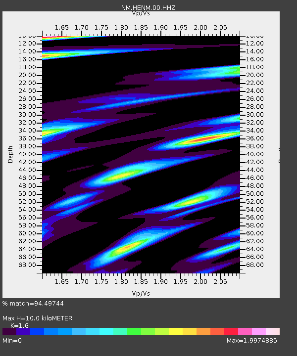
| Estimated Moho Depth: |
10.0 km |
| Estimated Crust Vp/Vs: |
1.60 |
| Assumed Crust Vp: |
6.444 km/s |
| Estimated Crust Vs: |
4.027 km/s |
| Estimated Crust Poisson's Ratio: |
0.18 |
|
| Radial Match: |
94.49744 % |
| Radial Bump: |
293 |
| Transverse Match: |
94.69819 % |
| Transverse Bump: |
315 |
| SOD ConfigId: |
1259291 |
| Insert Time: |
2015-11-21 08:25:26.423 +0000 |
| GWidth: |
2.5 |
| Max Bumps: |
400 |
| Tol: |
0.001 |
|

Signal To Noise
| Channel | StoN | STA | LTA |
| NM:HENM:00:HHZ:20151107T07:42:15.830012Z | 41.16397 | 1.2718602E-5 | 3.089741E-7 |
| NM:HENM:00:HHN:20151107T07:42:15.830012Z | 15.1117935 | 7.5946523E-6 | 5.025646E-7 |
| NM:HENM:00:HHE:20151107T07:42:15.830012Z | 7.578798 | 4.735405E-6 | 6.2482275E-7 |
| Arrivals |
| Ps | 1.0 SECOND |
| PpPs | 3.9 SECOND |
| PsPs/PpSs | 4.8 SECOND |


