You are here: Home > Network List > CI - Caltech Regional Seismic Network Stations List
> Station MUR Murrieta > Earthquake Result Viewer
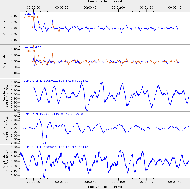
MUR Murrieta - Earthquake Result Viewer
*The percent match for this event was below the threshold and hence no stack was calculated.
| Earthquake location: |
Southeast Of Loyalty Islands |
| Earthquake latitude/longitude: |
-22.6/170.9 |
| Earthquake time(UTC): |
2009/01/19 (019) 03:35:18 GMT |
| Earthquake Depth: |
12 km |
| Earthquake Magnitude: |
5.7 MB, 6.4 MS, 6.5 MW, 6.5 MW |
| Earthquake Catalog/Contributor: |
WHDF/NEIC |
|
| Network: |
CI Caltech Regional Seismic Network |
| Station: |
MUR Murrieta |
| Lat/Lon: |
33.60 N/117.20 W |
| Elevation: |
562 m |
|
| Distance: |
88.3 deg |
| Az: |
52.527 deg |
| Baz: |
241.493 deg |
| Ray Param: |
$rayparam |
*The percent match for this event was below the threshold and hence was not used in the summary stack. |
|
| Radial Match: |
77.022095 % |
| Radial Bump: |
400 |
| Transverse Match: |
66.843056 % |
| Transverse Bump: |
400 |
| SOD ConfigId: |
2658 |
| Insert Time: |
2010-03-05 21:19:36.808 +0000 |
| GWidth: |
2.5 |
| Max Bumps: |
400 |
| Tol: |
0.001 |
|
Signal To Noise
| Channel | StoN | STA | LTA |
| CI:MUR: :BHN:20090119T03:47:38.691013Z | 5.221603 | 1.2976577E-6 | 2.4851713E-7 |
| CI:MUR: :BHE:20090119T03:47:38.691013Z | 0.9823932 | 2.3492507E-7 | 2.391355E-7 |
| CI:MUR: :BHZ:20090119T03:47:38.691013Z | 1.2730161 | 4.5438964E-7 | 3.5693944E-7 |
| Arrivals |
| Ps | |
| PpPs | |
| PsPs/PpSs | |


